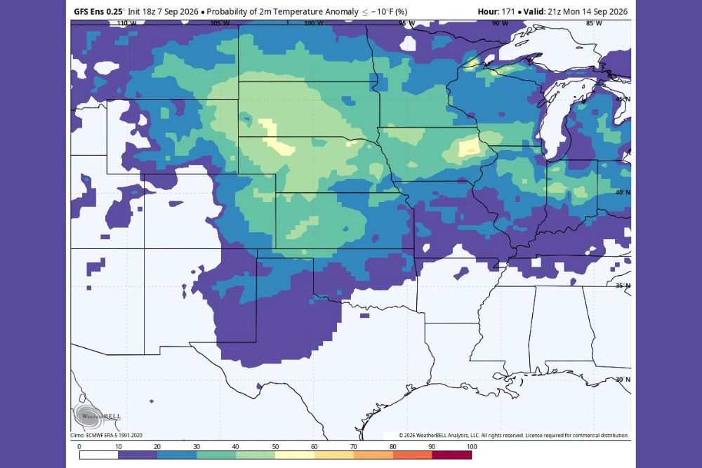
CENTRAL UNITED STATES — A significant cool-down signal is emerging across the nation’s midsection as GFS ensemble guidance points to a growing probability of temperatures running well below normal heading into the middle of September. The latest ensemble data, initialized September 7, 2026, highlights a broad swath of the Plains, Midwest, and portions of the Rockies where the chance of two-meter temperature anomalies dropping 10 degrees or more below normal continues to trend upward for the valid period around September 14.
Ensemble Data Shows Elevated Probabilities Through the Heartland
The probability map, generated from the GFS Ensemble 0.25-degree model, illustrates a corridor of elevated likelihood stretching from portions of Montana and Wyoming through Nebraska, Kansas, South Dakota, Iowa, and into Missouri and Illinois, where probabilities of a 10-degree-or-greater negative anomaly climb into the 50 to 70 percent range, with isolated pockets pushing even higher. This pattern reflects a broad area where ensemble members are increasingly aligned on a below-normal temperature outcome rather than a more scattered, low-confidence signal.
Forecasters tracking the ensemble spread note that when a large percentage of model members agree on a temperature departure this early in the outlook window, confidence in the eventual pattern tends to increase as the valid date approaches, even though day-to-day details can still shift depending on how the broader upper-level pattern evolves over the coming days.
Overnight Lows Expected to Fall Into the 40s Across Northern Tier
One of the more notable impacts tied to this developing pattern involves overnight low temperatures. Across the northern Plains and into the upper Midwest, including areas of North Dakota, South Dakota, Minnesota, and Wisconsin, nighttime temperatures are expected to fall into the 40s under this setup, with some locations farther north potentially dipping even lower depending on how the pattern ultimately evolves.
This kind of overnight chill would mark a sharp departure from typical mid-September conditions across the region, where average lows still commonly sit in the 50s in many areas. A shift of this magnitude illustrates how quickly the transition toward autumn air can take hold once an upper-level pattern favoring cooler air becomes established across the central part of the country, catching residents and businesses off guard if preparations lag behind the incoming change.
Southern and Eastern States Show Lower Probability Signals
Farther south and east, including much of Texas, Oklahoma, the Gulf Coast states, and the Southeast, probabilities of a 10-degree-or-greater cold anomaly remain comparatively low, generally in the 0 to 20 percent range on the ensemble guidance. This suggests that while the core of the below-normal air mass looks likely to settle over the nation’s midsection, warmer conditions are more likely to persist closer to typical September norms across the Gulf Coast and Southeastern states through the same period.
The sharp contrast between the cool signal over the Plains and Midwest and the more modest departures farther south underscores the regional nature of this pattern. It also highlights the importance of continuing to monitor model trends, since ensemble probabilities can shift as the forecast period draws closer and additional data is incorporated into the guidance used by forecasters across the affected states.
Pattern Bears Watching as Mid-September Approaches
With the valid time for this guidance centered on September 14, there remains time for adjustments in the ensemble solutions before the pattern fully arrives. However, the consistency of the signal across a large number of ensemble members lends some credibility to the idea that a genuine autumn-like intrusion of cooler air is on the table for a significant portion of the central United States.
Residents and outdoor event planners across the Plains and Midwest states highlighted in this outlook may want to keep an eye on evolving forecasts in the days ahead, particularly if overnight temperatures in the 40s could affect agricultural interests, outdoor activities, or heating needs earlier than typically expected in mid-September. Farmers with late-season crops still in the field and residents who have not yet transitioned their heating systems for the season may want to monitor updates closely as the pattern solidifies over the next several days.
For continuing coverage of shifting weather patterns and seasonal temperature outlooks across the United States, visit svhsnow.com.