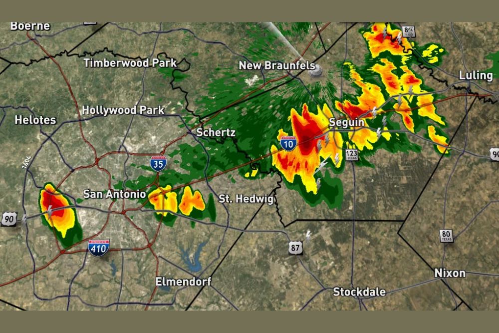
SAN ANTONIO, TX — A lone thunderstorm popped up near Highway 90 and 410 close to Lackland on Friday evening, with live radar showing the isolated cell developing around 9 PM alongside a few additional showers on the east side of San Antonio. Meanwhile, a more organized zone of rain accompanied by thunder has developed along Interstate 10 across Guadalupe County, with that activity moving slowly after forming along a nearby boundary.
Isolated Storm Develops Near Lackland
Radar imagery captured at 8:55 PM on Friday shows an isolated thunderstorm cell positioned near the intersection of Highway 90 and 410, close to the Lackland area on the western side of San Antonio. This lone storm appears as a distinct, more concentrated area of heavier radar returns separate from the broader zone of activity developing farther east along the I-10 corridor.
The isolated nature of this storm suggests it developed independently from the larger cluster of showers and thunderstorms taking shape near Seguin and New Braunfels, representing a separate area of localized convection rather than an extension of the more organized activity to the east.
Scattered Showers Also Affect East San Antonio
In addition to the isolated storm near Lackland, a couple of scattered showers were also noted on the east side of San Antonio, contributing to a broader pattern of hit-or-miss precipitation across the metro area on Friday evening. This kind of scattered coverage is typical for isolated convective activity that develops without a strong, organized forcing mechanism driving widespread storm development across the entire region simultaneously.
Radar data shows these scattered cells positioned generally along the US-90 corridor stretching toward Elmendorf, indicating the activity extended in a rough line across the southern and eastern portions of the San Antonio metro area during the evening hours.
Organized Rain and Thunder Zone Along I-10
The more substantial area of weather activity on Friday evening developed as a defined zone of rain accompanied by thunder along the Interstate 10 corridor, stretching across Guadalupe County through communities including Schertz, Seguin, and toward Luling. Radar imagery shows this activity as a more continuous and organized band compared to the scattered, isolated cells farther west near San Antonio proper.
This zone of rain and thunder developed directly along a boundary, which helped organize the moisture and instability into the more defined line visible on radar, in contrast to the more randomly scattered convection affecting other parts of the broader region.
Storms Moving Slowly After Forming Along the Boundary
Forecasters noted that the organized rain and thunder activity along I-10 has been moving slowly since developing along the nearby boundary, a characteristic that can extend the duration of rainfall for communities directly in the path of the activity. Slow-moving storms, even those not reaching severe criteria, can produce locally higher rainfall totals simply due to the extended time any one location spends under the associated precipitation.
Communities along the I-10 corridor in Guadalupe County, including Seguin and areas approaching Luling, should expect the rain and thunder to persist for a longer duration compared to a faster-moving system, given the sluggish forward motion described for this activity.
A Fairly Typical Late-Summer Evening Pattern
The combination of an isolated thunderstorm near Lackland, scattered showers on the east side of San Antonio, and a more organized rain and thunder zone along I-10 reflects a fairly common late-summer evening weather pattern for the San Antonio region. This type of scattered-to-organized convective mix often develops as daytime heating and available moisture interact with a weak boundary or other subtle atmospheric feature.
None of the activity captured in Friday evening’s radar imagery appears to represent a significant or widespread severe weather threat, consistent with the relatively routine nature of isolated and scattered thunderstorm development this time of year across South Central Texas.
What Residents Should Expect
Residents across the San Antonio metro area and into Guadalupe County should expect continued isolated to scattered shower and thunderstorm activity through the remainder of Friday evening, with the slow-moving rain and thunder along I-10 likely to persist longer for communities in that specific corridor. Given the relatively minor nature of tonight’s activity, no significant impacts are expected beyond typical wet-weather driving conditions and occasional thunder.
For continuing coverage of severe weather events and critical storm analysis across the United States, visit svhsnow.com.