GRAND JUNCTION, CO — Scattered showers and a few stronger storms will continue through the overnight hours and into tomorrow morning across the Colorado, Wyoming, and Nebraska region, as moisture surges into the area from the southwest ahead of a late Monday night cold front. Forecasters say this activity will be most numerous along and west of the Continental Divide, on the western slope, and extending into Wyoming and Nebraska.
Moisture Surge Fuels Overnight Activity
The overnight and early morning shower and storm activity is being driven by moisture surging into the region from the southwest, arriving ahead of a cold front expected to move through late Monday night. This influx of moisture is providing the fuel necessary for the scattered showers and occasional stronger storms visible on radar across the western portions of Colorado and into neighboring states.
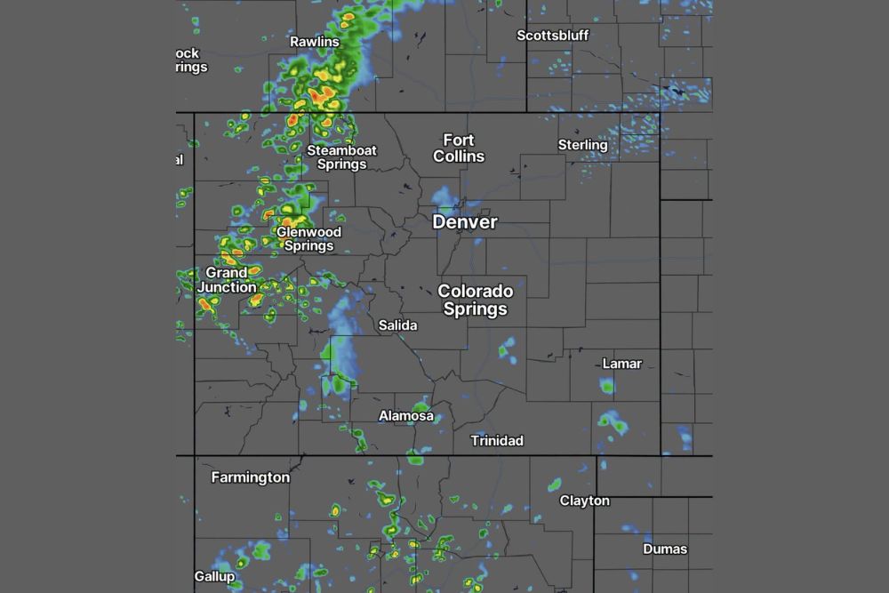
Radar imagery shows numerous cells of showers and storms scattered across a wide area, with some of the more intense activity, indicated by yellow and orange coloring, concentrated near Rawlins, Steamboat Springs, and Grand Junction, illustrating the kind of scattered but occasionally locally heavier precipitation typical of this moisture-driven setup.
Western Slope and Areas West of the Divide See the Most Activity
Forecasters specifically highlighted that this shower and storm activity will be most numerous along and west of the Divide and across the western slope region of Colorado. This geographic concentration reflects the pattern’s connection to the incoming moisture surge, which appears to be interacting most favorably with the terrain and atmospheric setup on the western side of the state.
Communities including Grand Junction, Glenwood Springs, and Steamboat Springs fall within this zone of greatest activity, with radar showing consistent shower and storm coverage across that corridor as the overnight hours progress.
Wyoming and Nebraska Also See Elevated Activity
Beyond the immediate Colorado western slope, forecasters noted that this pattern of scattered showers and storms extends into Wyoming and Nebraska as well, with radar showing notable activity near Rawlins in south-central Wyoming and scattered cells extending toward Scottsbluff in the Nebraska panhandle. This broader geographic reach illustrates how the moisture surge responsible for tonight’s activity spans a significant multi-state area rather than remaining confined to a single region.
The presence of more numerous and occasionally more intense cells near Rawlins suggests this area may see some of the more active weather within the broader zone highlighted for tonight’s overnight shower and storm potential.
A Late Monday Night Cold Front Sets the Stage
The overall weather pattern responsible for tonight’s activity is tied to an approaching cold front expected to move through the region late on Monday night. This front is serving as the broader forcing mechanism working in tandem with the surging southwesterly moisture to produce the scattered shower and storm coverage visible across the region this evening and overnight.
Once this front eventually clears the area, conditions are likely to shift, though the immediate forecast remains focused on the continuation of scattered shower and storm activity through the overnight hours and into tomorrow morning as the front continues its approach.
Activity Expected to Continue Into Tomorrow Morning
Forecasters indicated that this pattern of scattered showers and a few stronger storms will persist through the overnight hours and continue into tomorrow morning, rather than clearing out quickly after sunset. That extended timeline means residents across the affected region should expect the possibility of encountering wet or stormy conditions even during the early morning hours, depending on their specific location relative to the most active cells.
A morning update is planned for 6:30 AM tomorrow, suggesting forecasters intend to provide refreshed information on how the overnight activity has evolved and what conditions residents can expect as the new day begins across the region.
What Residents Should Expect
Residents across western Colorado, along with portions of Wyoming and western Nebraska, should expect continued scattered showers and the possibility of a few stronger storms through the overnight hours and into tomorrow morning. Given the geographic concentration of this activity along and west of the Divide, those areas in particular should remain prepared for wet conditions persisting through the early morning hours ahead of Monday night’s approaching cold front.
For continuing coverage of severe weather events and critical storm analysis across the United States, visit svhsnow.com.