MICHIGAN — A warm front moving through the state on Tuesday is set to bring a mix of weather conditions across Michigan, with showers and thunderstorms favoring the Upper Peninsula and northern Lower Michigan, while southern and central Michigan see less rain and noticeably warmer temperatures climbing into the lower 80s.
Warm Front Triggers Showers Across Northern Michigan
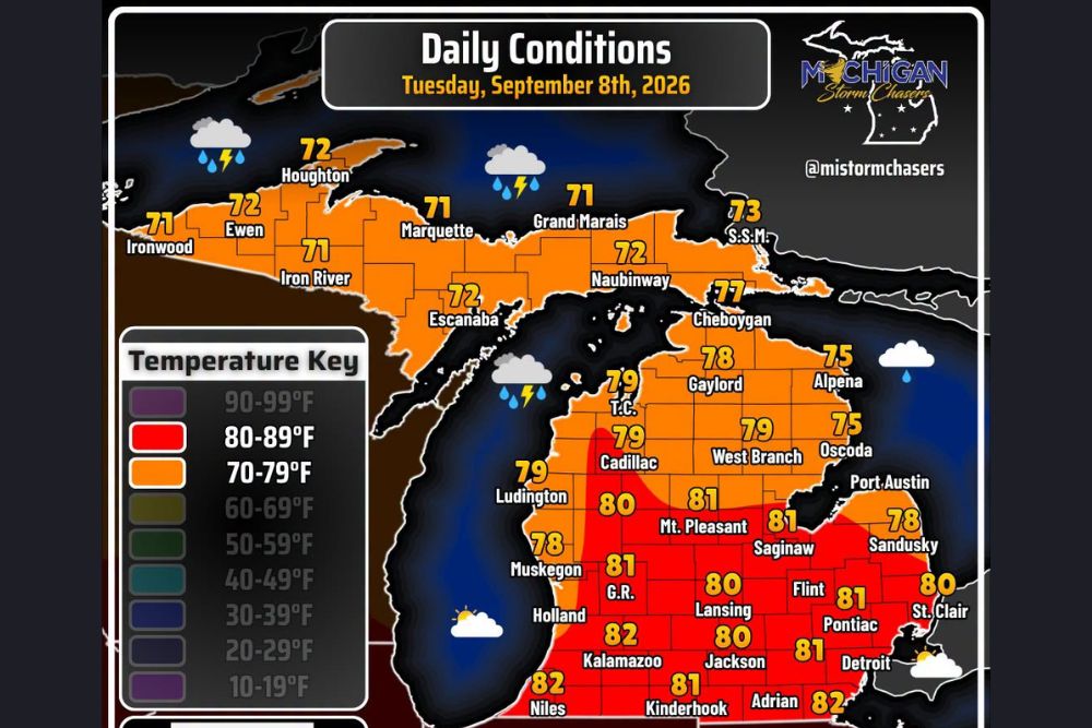
As the warm front pushes through the region, communities across the Upper Peninsula and northern Lower Michigan are expected to see periods of showers and thunderstorms throughout the day. Areas including Marquette, Grand Marais, Naubinway, and Sault Ste. Marie are forecast to see highs in the low 70s, with scattered rain activity tied directly to the frontal passage moving across the northern tier of the state.
Humidity levels are expected to increase behind the front as well, though forecasters note the added moisture is not expected to reach oppressive levels, keeping conditions manageable even with the additional shower and thunderstorm activity across the northern half of Michigan through the day Tuesday.
Southern and Central Michigan Set to See Warmer, Drier Conditions
While the northern half of the state contends with rain chances, southern and central Michigan are on track for a considerably drier and warmer Tuesday. High temperatures are expected to climb into the lower 80s across communities such as Kalamazoo, Lansing, Jackson, Grand Rapids, and Detroit, with less rainfall expected compared to areas farther north.
This temperature contrast highlights the transitional nature of the frontal boundary, with the warm sector settling in more firmly across the southern and central Lower Peninsula while the front itself continues to generate scattered convective activity closer to the Straits of Mackinac and points north.
Coastal Communities See Moderate Temperatures With Isolated Shower Chances
Areas along the eastern shoreline of the Lower Peninsula, including Alpena, Oscoda, and Port Austin, are forecast to see slightly cooler readings in the mid-to-upper 70s, with isolated shower activity possible as lake influence and the passing front interact along the coastline. Meanwhile, communities along the western shoreline, such as Ludington, Muskegon, and Holland, are expected to see mostly quiet conditions with highs in the upper 70s to low 80s.
This kind of temperature gradient between the coastal zones and the interior of the state is common during frontal passages, as lake-influenced air tends to moderate temperature swings near the shoreline compared to inland communities that warm more readily under partly sunny skies.
Tuesday Setup Reflects Typical Early September Transition
The overall pattern taking shape across Michigan on Tuesday reflects a fairly typical early September setup, with a frontal system delivering a round of rain to one part of the state while another portion enjoys a milder, drier day under the influence of a building warm sector. Temperatures across the state Tuesday are expected to range from the low 70s in the far north to the low 80s across the southern Lower Peninsula, illustrating the sizable north-to-south contrast tied to the frontal boundary’s position.
Residents across Michigan, particularly those in the Upper Peninsula and northern Lower Michigan, should stay weather aware Tuesday as scattered storms move through, while those farther south can expect a warmer, mostly dry day as high pressure builds in behind the departing system.
For continuing coverage of daily forecasts and severe weather tracking across the United States, visit svhsnow.com.