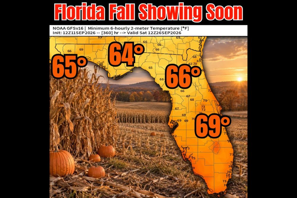
TALLAHASSEE, FL — Cooler overnight temperatures are trending for Florida as both the GFS and European model are hinting at readings dipping into the 60s in a couple of weeks, potentially arriving before October even begins. Forecasters say the setup points toward the Sunshine State’s first real taste of fall-like weather, complete with cooler nights suited for firepits and the kind of crisp air that makes pumpkin spice season feel official.
Model Data Points to a Statewide Cool-Down
The latest NOAA GFSv16 model run, initialized at 12z on September 11 and valid for Saturday, September 26, shows minimum overnight temperatures dropping into the 60s across nearly the entire state of Florida. The Panhandle region, including areas near Tallahassee, is projected to see the coolest readings, with forecast lows reaching 64 to 65 degrees.
Farther south and east, projected minimum temperatures remain slightly milder but still notably cool for Florida standards, with northeast Florida near Jacksonville forecast at 66 degrees and central Florida, including areas around Orlando and toward the Space Coast, projected to see lows near 69 degrees.
Both Major Models Show Agreement on the Trend
Forecasters specifically highlighted that both the GFS and the European model, two of the most widely used global forecast models, are showing consistent hints of this cooler pattern developing in the 60s timeframe. That agreement between two separate modeling systems adds a measure of confidence to the overall trend, even though specific details this far out remain subject to typical long-range forecast uncertainty.
This kind of cross-model consistency is often viewed favorably by meteorologists, since two independently developed forecast systems arriving at similar conclusions suggests the underlying atmospheric signal driving the cooler pattern may be a genuine and identifiable feature rather than model noise.
Timing Points to Before October Arrives
Perhaps the most notable detail in this outlook is the timing, with forecasters indicating the cooler readings could arrive before October even begins, based on the model run valid for September 26. That timeline would represent an unusually early arrival for fall-like overnight temperatures across Florida, a state that typically holds onto warmer conditions well into the autumn months compared to much of the rest of the country.
If this trend verifies, it would offer Florida residents a meaningfully earlier transition toward cooler weather than what the state has experienced in many recent years, giving an early boost to the sense that fall is finally on its way even in one of the nation’s warmest states.
Coolest Readings Expected in the Panhandle
Consistent with typical Florida temperature patterns, the Panhandle region is forecast to see the most significant cooling, with projected lows in the mid-60s compared to the upper 60s and low 70s expected farther south. This gradient reflects the Panhandle’s more northern latitude and its greater exposure to cooler air masses moving in from the continental United States compared to the peninsula’s more tropical, maritime-influenced climate.
Communities across the Panhandle, including areas surrounding Tallahassee, are likely to notice the most pronounced shift toward comfortable, fall-like evenings once this predicted cool-down arrives, offering an earlier and more distinct seasonal transition compared to areas farther south on the peninsula.
South Florida Sees More Modest Cooling
Even the southernmost portions of the state are not left out of this cooling trend entirely, with model data showing minimum temperatures dropping into the low-to-mid 70s across South Florida, including areas near Miami and the Florida Keys. While not as dramatic as the 60s expected farther north, this would still represent a meaningful, noticeable improvement from the warmer, more humid overnight lows typical of late summer in South Florida.
That statewide reach, even if the magnitude of cooling varies significantly from the Panhandle to South Florida, underscores just how broad this potential pattern shift could be if the current model trends continue to hold as the timeframe approaches.
What This Could Mean for Florida Residents
If this cooling trend materializes as both models are currently suggesting, Florida residents could be looking at their first genuinely comfortable, fall-like nights of the season arriving even before the official first day of fall, or shortly after it, depending on the specific date. That would offer an early window for outdoor evening activities, firepit gatherings, and the kind of crisp air that many residents associate with the changing of seasons, even in a state known for its long, warm summers.
Forecasters cautioned that while both models show consistent hints at this pattern, two weeks remains enough time for meaningful changes to occur in the specific timing and magnitude of any cool-down, meaning continued monitoring will be important as the forecast period draws nearer.
For continuing coverage of severe weather events and critical storm analysis across the United States, visit svhsnow.com.