DES MOINES, IA — Forecasters are warning of life-threatening flash flooding as multiple rounds of thunderstorms are expected to move through the Midwest from this weekend through the middle of next week, with a stalled boundary raising the potential for isolated rainfall totals reaching as high as 7 to 10 inches across portions of Iowa, Illinois, Missouri, and Nebraska. While this weekend’s rain likely won’t be overly impressive on its own, forecasters say it appears to be the beginning of a much wetter pattern taking hold across the region.
A Multi-Day Setup Builds Through Next Week
Signals have remained consistent across forecast models for multiple rounds of thunderstorms developing from this weekend through Thursday of next week, according to the latest outlook. This extended timeline suggests the region is heading into an unusually prolonged stretch of active, rain-producing weather rather than a single, short-duration storm system passing through.
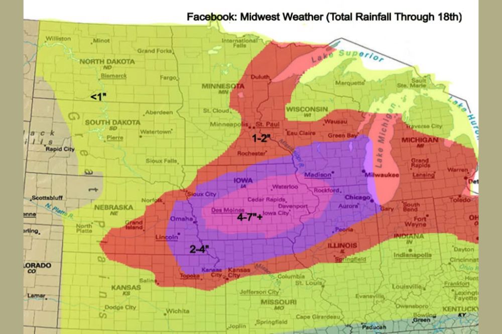
Forecast rainfall mapping through the 18th shows the heaviest totals concentrated in a corridor stretching from Nebraska through Iowa and into Illinois, with a narrower band of the most extreme totals running through Sioux City, Cedar Rapids, Des Moines, and toward Chicago.
Stalled Boundary Sets Up Repeated Training Storms
The primary driver behind the potential for extreme rainfall totals is a stalled boundary that is expected to become the focus for what meteorologists call training thunderstorms, a pattern in which repeated storm cells move over the same geographic area one after another. This training effect allows rainfall totals to climb rapidly in a concentrated zone, since each successive storm adds to the accumulation already on the ground from the storms before it.
From Monday through Thursday specifically, forecasters say repeated rounds of thunderstorms could produce very heavy rainfall rates of 0.50 to 1.00 inches per hour, especially across portions of Iowa, Illinois, Missouri, and Nebraska, a rate capable of quickly overwhelming drainage systems and low-lying terrain.
Isolated Totals Could Reach 7 to 10 Inches
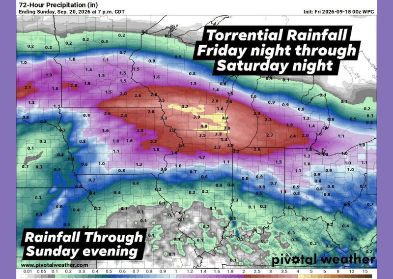
While forecasters emphasized that widespread 7 to 10 inch rainfall totals are not expected across the entire region, isolated areas within the stalled boundary’s path could potentially reach that range, raising the risk of significant and potentially major flooding in those specific locations. Forecast mapping highlights a zone covering much of central and eastern Iowa, extending into northern Illinois, as the area most likely to see totals in the 4 to 7 inch or greater range.
Surrounding areas, including much of Nebraska, southern Minnesota, and portions of Missouri, are forecast to see somewhat lower but still substantial totals generally in the 1 to 4 inch range, with the outer edges of the highlighted zone seeing under an inch as the system’s influence tapers off.
Flash Flooding Remains One of the Deadliest Weather Hazards
Forecasters were direct in their messaging about the seriousness of this setup, noting that flash flooding remains one of the deadliest weather hazards in the United States. That statistic underscores why officials are urging residents across the affected states to take this potential multi-day rain event seriously rather than dismissing it as an ordinary rain forecast.
The combination of an unusually long duration, repeated training storms, and the potential for extreme localized totals creates a scenario where flash flooding could develop with limited warning, particularly in areas that see the heaviest, most persistent rainfall bands set up directly overhead.
Communities Across Four States Face Elevated Risk
The broader area of concern spans a significant portion of the central Midwest, with cities including Des Moines, Cedar Rapids, Waterloo, and Davenport in Iowa, along with Chicago, Rockford, and Peoria in Illinois, all falling within or near the zone forecast to see the heaviest rainfall. Communities in Nebraska, including Omaha, Lincoln, and Norfolk, along with portions of Missouri near Kansas City and St. Louis, are also within the broader area expected to see elevated rainfall from this developing pattern.
Given the size of the area under threat and the multi-day timeline involved, officials are treating this as a regionally significant flooding concern rather than an isolated, localized event affecting just one or two communities.
What Residents Should Do to Stay Safe
Officials are urging residents across the affected states to stay weather-aware throughout the coming week and to never attempt to drive through flooded roadways, a warning that reflects how most flood-related fatalities occur when vehicles are swept off roads during high water. Residents in areas prone to flooding should have an evacuation plan ready and should monitor local alerts closely as the multi-day event unfolds.
Given the potential for isolated extreme totals and the deadly nature of flash flooding, officials emphasized the importance of being prepared before the heaviest rain arrives, rather than waiting until floodwaters are already rising to take protective action.
For continuing coverage of severe weather events and critical storm analysis across the United States, visit svhsnow.com.