TALLAHASSEE, FL — Central and North Florida are finally getting a genuine taste of fall, with a front expected to pass through bringing gusty winds and a welcome drop in humidity from Wednesday into Thursday. Forecasters say dew points, a measure of humidity, will fall 5 to 10 degrees, combined with wind gusts reaching up to 30 mph, delivering a brief but refreshing break from the region’s steamy summer weather pattern.
A Front Brings Gusty Winds and Lower Humidity
The approaching front is expected to usher in noticeably gusty conditions as it passes through Central and North Florida, with winds gusting up to 30 mph accompanying the drop in humidity. This combination of wind and drier air is what will create the refreshing, fall-like feel forecasters are highlighting for this brief stretch of improved weather.
The drop in dew points of 5 to 10 degrees represents a meaningful shift in how the air will actually feel to residents, since dew point, rather than temperature alone, is often the more accurate measure of how muggy or comfortable conditions feel outdoors, particularly in a humid climate like Florida’s.
Dew Points Data Shows a Statewide Improvement
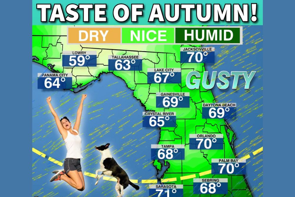
Forecast dew point data for Wednesday afternoon shows a clear pattern of improving conditions stretching across the northern half of the state, with the Panhandle region seeing the most dramatic drop. Lowry is projected to see dew points fall to 59 degrees, while Tallahassee is forecast at 63 degrees and Panama City at 64 degrees, representing some of the driest, most comfortable air of the stretch.
Moving eastward and southward, dew points remain in a more moderate range, with Gainesville at 69 degrees, Crystal River at 65 degrees, and Lake City at 67 degrees, still representing an improvement over the region’s typical steamy summer conditions even if not quite as dramatic as the readings farther west.
Central Florida Sees a More Modest Improvement
Communities across Central Florida are forecast to see a comparatively smaller drop in humidity, with dew points generally holding in the 68 to 71 degree range. Tampa is projected at 68 degrees, Orlando and Daytona Beach both near 70 degrees, and Sarasota reaching 71 degrees, reflecting a more modest but still noticeable shift compared to typical late-summer humidity levels in that part of the state.
Jacksonville, Palm Bay, and Sebring round out the Central and North Florida readings, all falling in the upper-60s to 70-degree range, illustrating that while the most dramatic improvement remains concentrated in the Panhandle and Big Bend regions, the effects of this front extend across a broad stretch of the state.
A Short-Lived Window Before Business as Usual Returns
Forecasters were direct in noting that this refreshing break will be brief, cautioning residents not to blink or they’ll miss it entirely. By Friday, conditions are expected to return to business as usual, meaning the steamy, humid summer-like pattern that has dominated much of the season will reestablish itself across the region once the front moves through and its effects fade.
This short duration underscores the fleeting nature of early fall pattern breaks in Florida, where truly comfortable, lower-humidity conditions often arrive in brief pulses rather than settling in for an extended stretch, particularly this early in the transition toward cooler weather.
South Florida Left Waiting a Few More Weeks
Unlike Central and North Florida, forecasters were clear that South Florida will not see the benefits of this particular front, meaning residents in that region will need to wait a few more weeks before experiencing any comparable relief from the summer humidity. This geographic split reflects how cold fronts moving into Florida frequently lose their punch before reaching the southern peninsula, a common pattern during the early stages of the state’s gradual transition toward fall.
That distinction matters for South Florida residents planning around this forecast, as the drop in dew points and the accompanying gusty, more comfortable conditions described for the northern and central parts of the state are not expected to extend into the southern reaches of the peninsula with this particular system.
What Residents Should Expect
Residents across Central and North Florida should enjoy the brief window of gusty, lower-humidity conditions arriving Wednesday into Thursday, recognizing that this represents a short-lived taste of fall rather than a lasting pattern change. By Friday, conditions are expected to revert to the region’s typical late-summer humidity and warmth, meaning residents should take advantage of the more comfortable stretch while it lasts.
For continuing coverage of severe weather events and critical storm analysis across the United States, visit svhsnow.com.