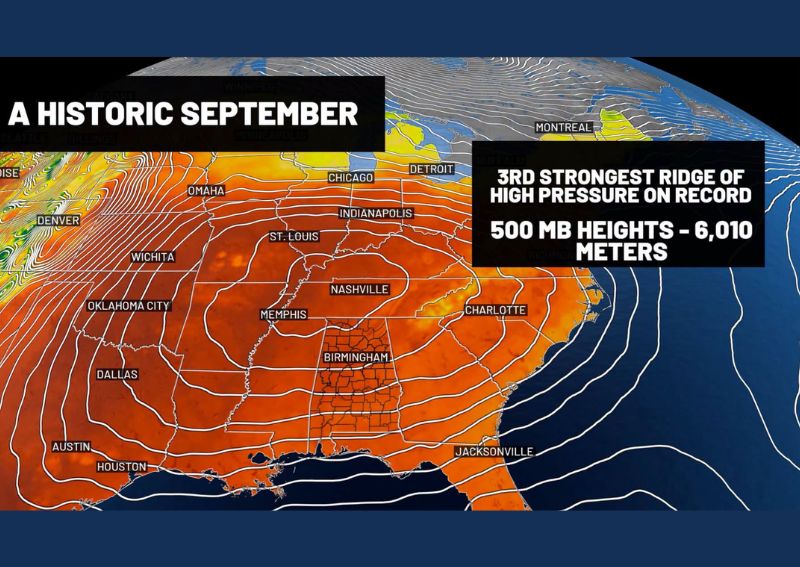
BIRMINGHAM, AL — An exceptionally strong ridge of high pressure has settled over the southeastern United States, driving one of the most historic September heat patterns on record across Alabama. A weather balloon launch from Birmingham measured the 500-millibar height at 6,010 meters, tying for the third-highest reading ever recorded at that location. Meteorologists say this atmospheric measurement helps explain why the recent heat has felt so relentless and why meaningful rainfall has been almost impossible to find across the region in recent weeks.
Multiple Alabama Cities Setting or Tying Records
The scale of this heat event is reflected across numerous Alabama communities tracking their warmest early September on record. Birmingham is currently tying 1925 for the warmest September 1–15 period on record, while Montgomery is sitting at its third-hottest such stretch, with 1925 still holding the top spot. Shelby County has recorded its hottest such period in the past 30 years of available data, underscoring how widespread and significant this heat event has become across the region.
Records Dating Back Decades Falling in Several Cities
Beyond the metro areas, several additional Alabama communities are setting records that stretch back generations. Tuscaloosa is experiencing its hottest September 1–15 period since local records began in 1948, while Anniston is seeing its hottest stretch since records started in 1945. Gadsden rounds out the list with its hottest such period since record-keeping began in 1953, illustrating just how exceptional and geographically widespread this early September heat pattern has been.
Atmospheric Data Confirms the Heat Is Historic
The 500-millibar height measurement of 6,010 meters taken over Birmingham provides atmospheric confirmation that this heat event extends well beyond simple ground-level temperature readings. This measurement reflects the strength of the ridge of high pressure sitting overhead, and a reading this high indicates an unusually robust and persistent atmospheric pattern. Meteorologists note that both ground-level temperatures and upper-atmosphere conditions have been running at historic levels simultaneously, reinforcing that this heat event is far from typical September warmth.
Relief Expected as More Seasonal Air Arrives
While the current pattern has produced little in the way of meaningful rainfall, forecasters note that scattered rain and storm chances are expected to return over the next two days as the ridge of high pressure begins to weaken. More significant relief in the form of seasonal air is anticipated to arrive by the middle of next week, offering Alabama residents their first real break from the historic heat pattern that has dominated the region throughout early September.
For continuing coverage of severe weather events and critical storm analysis across the United States, visit svhsnow.com.