PHOENIX, AZ — Half a year’s worth of rain fell today in parts of Phoenix, with the east and north Valley seeing the heaviest totals as Mesa, Cave Creek, and Scottsdale recorded between 3 and 4 inches of rainfall. The dramatic single-day totals mark one of the more significant rain events the Valley has experienced in recent memory, given how much accumulated in such a short period.
East and North Valley See the Heaviest Totals
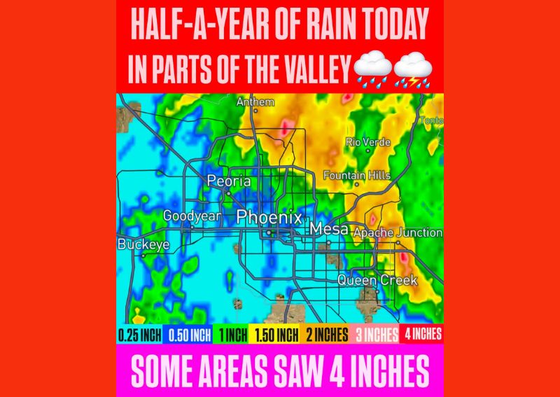
Rainfall mapping shows the most intense totals concentrated across the east and north Valley, with a corridor stretching from Anthem and Rio Verde in the north through Fountain Hills, Mesa, and Apache Junction in the east all falling within the 2 to 4 inch range. The darkest red shading on the map, indicating the highest totals near 4 inches, appears scattered across portions of this eastern corridor, particularly near Fountain Hills and Apache Junction.
This concentration of heavy rainfall across the eastern and northern portions of the metro area reflects how localized today’s most intense rain bands became, even as the broader storm system affected a much wider footprint across the entire Phoenix metropolitan region.
Central Phoenix Sees More Moderate Totals
Moving toward central Phoenix and the surrounding core of the metro area, rainfall totals moderate somewhat, generally falling in the 1 to 2 inch range based on the yellow and orange shading covering much of the central Valley. This still represents a substantial rainfall total for a single day, even though it falls short of the more extreme amounts recorded farther east.
Communities including Peoria and portions of central Phoenix itself fall within this moderate rainfall zone, still experiencing meaningful accumulation from today’s system even without reaching the most extreme totals recorded closer to the eastern Valley communities.
Western Valley Communities See Lighter Amounts
The western Valley, including Goodyear and Buckeye, saw comparatively lighter rainfall, with totals generally in the 0.25 to 1 inch range based on the blue and green shading covering that portion of the map. While still a meaningful rain event for these communities, the totals fall well short of the dramatic 3 to 4 inch amounts recorded in the eastern and northern portions of the Valley.
This west-to-east gradient in rainfall totals illustrates how significantly precipitation intensity varied across the Phoenix metro area during today’s event, with some communities separated by only a matter of miles experiencing dramatically different rainfall outcomes from the same overall storm system.
What Half a Year of Rain Really Means
Describing today’s rainfall as half a year’s worth puts the scale of this event into meaningful perspective for a desert region like Phoenix, where annual rainfall totals are typically modest compared to much of the rest of the country. Receiving several inches of rain in a single day represents an enormous portion of what the area would normally expect to see accumulate across many months, underscoring just how unusual and significant today’s rain event has been.
This kind of dramatic single-day accumulation is particularly notable for desert communities, where infrastructure and drainage systems are often designed around much lower typical rainfall expectations compared to wetter regions of the country.
Queen Creek and Surrounding Communities Also Affected
Communities including Queen Creek, positioned in the southeastern portion of the Valley, also fall within the zone of meaningful rainfall accumulation shown on today’s map, with totals in that area generally trending toward the higher end of the moderate range. The broad reach of today’s rainfall across so many distinct Valley communities, from Anthem in the north to Queen Creek in the southeast, illustrates the scale of today’s overall weather event.
Some Areas Saw the Full 4 Inches
Forecasters specifically highlighted that some areas saw the maximum 4 inches shown on today’s rainfall scale, representing the highest recorded totals from this event. Reaching this benchmark in any location underscores just how intense the heaviest rain bands became as they moved through portions of the eastern and northern Valley today.
What Residents Should Expect
Given the substantial rainfall recorded across much of the Phoenix metro area today, particularly the 3 to 4 inch totals in Mesa, Cave Creek, and Scottsdale, residents throughout the Valley should remain aware of potential lingering effects, including standing water and possible drainage issues in low-lying areas. Those in the eastern and northern Valley communities that saw the heaviest totals should exercise particular caution in areas prone to ponding following such a significant rainfall event.
For continuing coverage of severe weather events and critical storm analysis across the United States, visit svhsnow.com.