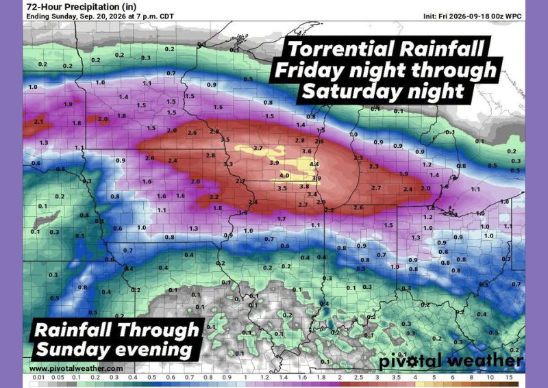
CENTRAL ILLINOIS — Two separate waves of heavy thunderstorms are expected to move through central Illinois beginning Friday night and continuing through Saturday night, with forecasters warning that both rounds could produce torrential rainfall capable of triggering flooding. The first wave is projected to arrive Friday night into Saturday morning, followed by a second round moving through Saturday afternoon into Saturday night. A 72-hour precipitation analysis shows the heaviest rainfall totals, ranging from 3.5 to 4.4 inches, concentrated across a band stretching through central Illinois into portions of eastern Iowa.
Heaviest Rainfall Band Targets Central Corridor
Forecast precipitation totals show the most intense rainfall setting up along a corridor cutting directly through central Illinois, with localized amounts reaching as high as 4.4 inches by Sunday evening. This heavy-rainfall band extends westward into eastern Iowa, with totals near 2 to 2.1 inches in that region, while areas farther south and east of the primary corridor are expected to see comparatively lighter totals in the 1 to 2 inch range. The concentrated nature of the heaviest rainfall raises the potential for training thunderstorms to repeatedly impact the same communities.
Flooding Risk Tied to Repeated Heavy Downpours
The primary hazard associated with this system is the potential for flooding, driven by the combination of two separate rounds of thunderstorms capable of producing torrential rainfall in a short period. When storms repeatedly track over the same areas, rainfall can accumulate faster than the ground or drainage systems can handle, increasing the risk of both localized street flooding and more significant flooding along smaller waterways. Residents across the highlighted rainfall corridor should monitor conditions closely as both storm rounds move through the region.
Damaging Wind Gusts Possible Saturday Afternoon
In addition to the flooding threat, forecasters note that storms moving through during the Saturday afternoon round could become strong enough to produce damaging wind gusts, adding a secondary hazard to the multi-day severe weather setup. This afternoon timing coincides with the period of peak daytime heating, which can help fuel stronger, more organized thunderstorm activity capable of producing gusty, damaging winds alongside the heavy rainfall already expected across the region.
Drier Conditions Expected by Sunday
Relief from the multi-day rain event is expected to arrive by Sunday morning, when the system is forecast to exit the region and allow drier conditions to move in later in the day. Rainfall totals will depend heavily on exactly how the two rounds of thunderstorms track and how much training occurs within the heaviest band, but forecasters currently expect the corridor through central Illinois to see the most significant impacts before conditions improve heading into early next week.
For continuing coverage of severe weather events and critical storm analysis across the United States, visit svhsnow.com.