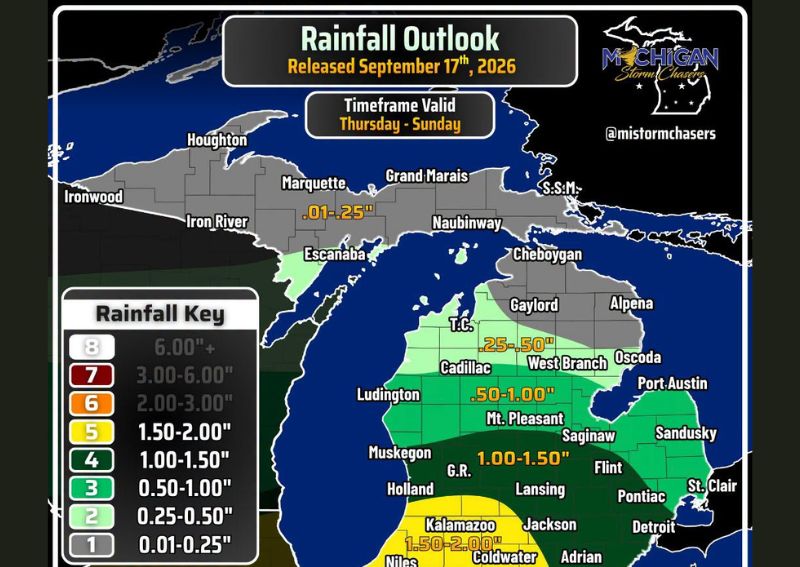
LANSING, MI — Another round of widespread rain is set to move into Michigan beginning Friday night and continuing through Saturday, following a brief quieter stretch earlier in the week. The heaviest rainfall totals are expected across Lower Michigan, where many areas could pick up between 1 and 1.5 inches through the weekend. Southwest Michigan communities, including Kalamazoo, Jackson, and Coldwater, are forecast to see even higher totals ranging from 1.5 to 2 inches, with isolated amounts exceeding 2 inches possible where heavier showers and thunderstorms repeatedly track over the same locations.
Heaviest Totals Target Southwest Lower Michigan
The greatest rainfall potential through the weekend is concentrated across southwest Lower Michigan, encompassing communities such as Kalamazoo, Coldwater, and Niles. Forecast totals in this zone range from 1.5 to 2 inches, with the possibility of isolated pockets receiving more than 2 inches if repeated rounds of showers and thunderstorms settle over the same areas for an extended period. This kind of training storm pattern can significantly boost localized rainfall totals compared to surrounding regions.
Central and Southern Michigan See Solid Totals
Moving into central and southern portions of Lower Michigan, including areas around Lansing, Jackson, Flint, and Detroit, rainfall totals are expected to generally fall in the 1 to 1.5 inch range through the weekend. Grand Rapids and Muskegon are positioned near the transition zone between the heaviest southwest totals and the more moderate amounts expected across the central Lower Peninsula, meaning some uncertainty remains in exactly how the heaviest band will set up.
Northern Michigan and the U.P. See Lighter Totals
Rainfall amounts drop off considerably farther north across the state. Northern Lower Michigan, including areas near Cadillac, West Branch, and Gaylord, is expected to see generally 0.25 to 1 inch of rain through the forecast period. Much of the Upper Peninsula, including Marquette, Ironwood, and Iron River, is forecast to receive considerably lighter totals, generally under a quarter inch, as the bulk of the moisture remains focused across the Lower Peninsula.
Forecast Details Expected to Sharpen
Forecasters note that rainfall totals and the exact placement of the heaviest band will continue to be fine-tuned as the weekend approaches, particularly in identifying where the most persistent showers and thunderstorms are likely to set up. Residents across Lower Michigan, especially in the southwest counties facing the highest totals, should stay alert for updated guidance as confidence in specific local amounts improves closer to the event.
For continuing coverage of severe weather events and critical storm analysis across the United States, visit svhsnow.com.