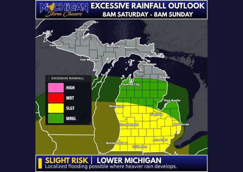
GRAND RAPIDS, MI — The Weather Prediction Center has placed southern Lower Michigan under a Slight Risk for excessive rainfall heading into the weekend, with a broader Marginal Risk extending farther north across the state. The outlook is valid from 8 AM Saturday through 8 AM Sunday, covering a wide stretch of the Lower Peninsula that includes Grand Rapids, Saginaw, Ann Arbor, Port Huron, and Benton Harbor. Forecasters warn that periods of heavier rain moving through the region could lead to localized flooding, particularly in areas that have already seen repeated rounds of rain in recent days.
Slight Risk Zone Covers Populated Southern Counties
The Slight Risk designation stretches across a large portion of southern Lower Michigan, encompassing major population centers including Grand Rapids, Saginaw, Ann Arbor, Coldwater, and Port Huron. This risk level indicates that scattered instances of excessive rainfall are considered likely enough to produce isolated flooding impacts, especially in low-lying or drainage-poor areas. The Marginal Risk zone extends the concern farther north, reaching toward Traverse City, Pentwater, and Port Austin, though with a lower probability of significant rainfall totals compared to the core Slight Risk area.
Saturated Ground Raises Flooding Concern
A key factor driving concern for this weekend’s outlook is the condition of the ground heading into the rain event. Areas that have already received repeated rounds of rain in recent weeks are considered more vulnerable to rapid runoff and localized flooding, since already-saturated soil has limited capacity to absorb additional rainfall. Forecasters emphasize that even moderate rain totals could translate into flooding impacts on roads and in low-lying neighborhoods across the highlighted Slight Risk zone.
Northern Michigan Included in Broader Marginal Risk
While the most significant rainfall potential is concentrated across southern Lower Michigan, the Marginal Risk designation extends coverage northward into areas surrounding Cheboygan, Alpena, and Munising in the eastern Upper Peninsula. This broader zone reflects a lower but still present chance of locally heavy rainfall capable of causing minor flooding issues, particularly where storms train over the same locations for extended periods during the outlook window.
Safety Reminder for Weekend Travel
With the rainfall outlook spanning the full weekend commute and travel period, forecasters are urging residents across Lower Michigan to exercise caution on the roadways. Motorists who encounter a flooded roadway are advised not to attempt driving through it, as water depth and road conditions can be difficult to judge, particularly at night or during heavy downpours. Turning around and finding an alternate route remains the safest option whenever flooded roads are encountered this weekend.
For continuing coverage of severe weather events and critical storm analysis across the United States, visit svhsnow.com.