CEDAR RAPIDS, IA — A cluster of severe thunderstorms is tracking eastward across Iowa on Tuesday night, prompting warnings for communities near Cedar Rapids and Waterloo, though forecasters say the storms are expected to weaken significantly before reaching the Illinois border. Meanwhile, showers and thunderstorms will remain a common feature across northern Illinois overnight, though no severe weather is expected on that side of the border.
Severe Storms Currently Active Across Eastern Iowa
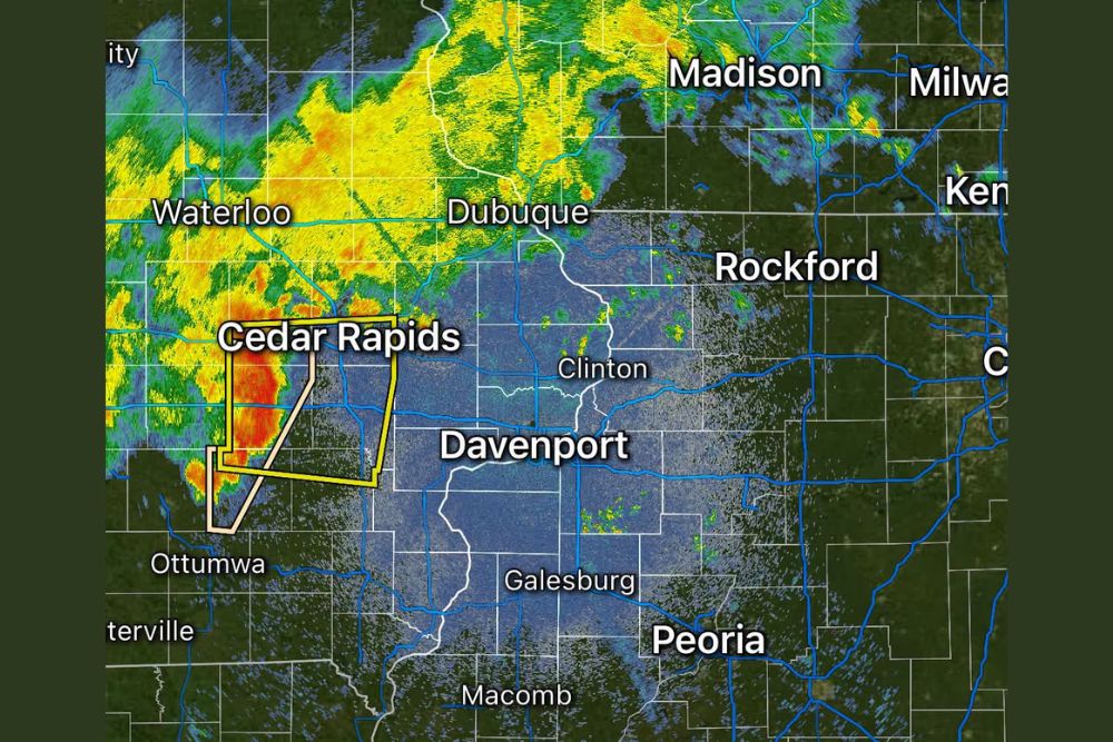
Radar data shows an area of severe thunderstorms currently impacting Cedar Rapids and extending southward toward Ottumwa, with a warning polygon outlining the area under the greatest threat as the cells continue their eastward motion. The storms are producing the kind of intense radar signature typically associated with locally heavy rainfall and the potential for gusty winds within the warned area.
Farther north, additional showers and storms are visible on radar stretching from Waterloo toward Dubuque, contributing to an active weather pattern across a wide swath of eastern Iowa during the Tuesday evening and overnight hours.
Storms Expected to Weaken Before Reaching Illinois
Despite the current severity of the storms over Iowa, forecasters were clear that the cells are expected to lose intensity as they continue tracking eastward, meaning communities in Illinois should not expect the same severe weather threat currently affecting Cedar Rapids and surrounding areas. This weakening trend is common for evening thunderstorm clusters that lose access to daytime heating and instability as they move across state lines overnight.
The transition from severe to non-severe intensity is expected to occur somewhere over the Mississippi River corridor, with cities including Dubuque, Clinton, and Davenport likely to see the storms in a diminished state compared to their current strength farther west.
Northern Illinois Sees Common but Non-Severe Activity
Across northern Illinois, including areas near Rockford and extending toward Chicago’s western suburbs, showers and thunderstorms are expected to remain a common feature of the overnight forecast, though forecasters emphasized that no severe weather is anticipated for that region. This represents a more typical overnight rain pattern rather than the more intense activity currently unfolding across parts of eastern Iowa.
Communities including Rockford, Kenosha, and areas near the Wisconsin border are within the broader zone expected to see periods of rain and rumbles of thunder overnight, consistent with a weakening frontal boundary moving through the region.
A Relatively Quiet Overnight Compared to Recent Days
Forecasters characterized Tuesday night’s setup as relatively uneventful compared to some of the more active weather days the region has seen recently, noting that the combination of weakening storms moving in from Iowa and non-severe showers already in place across northern Illinois adds up to a manageable overnight period for most residents. The absence of any severe weather threat for Illinois specifically was highlighted as a positive development given the currently active radar picture over Iowa.
That said, residents across the Cedar Rapids and Waterloo areas of Iowa should continue monitoring conditions closely while the current severe thunderstorm activity remains ongoing, even as the broader trend points toward weakening conditions by the time the system reaches the Illinois border.
Looking Ahead Through the Overnight Hours
As the current round of storms continues its eastward progression, the greatest concerns remain localized to eastern Iowa, where the severe thunderstorm warning remains active for the Cedar Rapids corridor. Once the boundary and associated storms cross into Illinois, expectations point toward a steady but non-severe rain and thunderstorm pattern continuing across the northern part of the state through the overnight hours.
Residents throughout the affected region are encouraged to stay weather-aware through the night, particularly those still within the active warning area in eastern Iowa, even as the overall outlook trends toward a quieter transition into Wednesday.
For continuing coverage of severe weather events and critical storm analysis across the United States, visit svhsnow.com.