OKLAHOMA CITY, OK — After a stretch of quieter weather, radar activity is expected to light up dramatically across northern Oklahoma and southern Kansas into Missouri beginning Wednesday afternoon, as an approaching cold front sets the stage for multiple rounds of rain and storms through Thursday. The system will progressively push south through the day Thursday, eventually carrying storm chances all the way down to the Red River by Thursday afternoon.
Storms Fire Along the Kansas-Oklahoma Border Wednesday
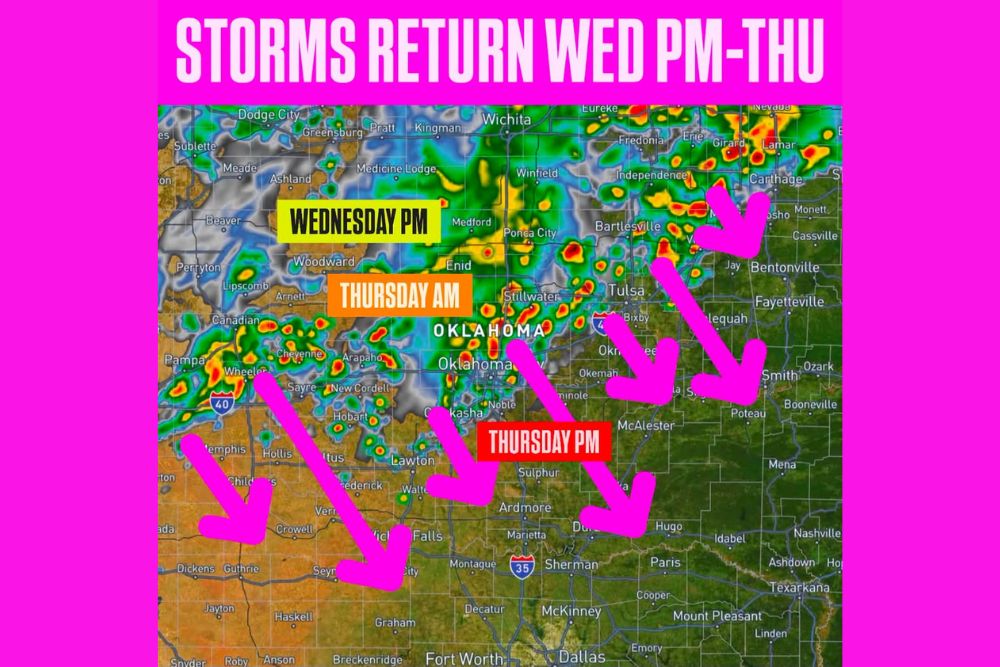
The first wave of activity is expected to develop Wednesday afternoon and evening, with radar data showing storms firing along a corridor stretching from Dodge City and Wichita in Kansas southward into northern Oklahoma communities including Enid, Ponca City, and Bartlesville. This initial round is forecast to intensify as it tracks southeastward, with some cells showing the potential for locally heavier rainfall.
Forecasters compared the expected radar appearance to a Christmas tree effect, a description meteorologists often use when numerous individual storm cells light up simultaneously across a broad area, reflecting how active the atmosphere is expected to become as the front approaches from the northwest.
Cold Front Drops South Through Oklahoma Thursday Morning
By Thursday morning, the boundary is forecast to have pushed into central Oklahoma, bringing rain and storms along the Interstate 40 corridor through cities including Oklahoma City, Tulsa, and Stillwater. The front’s steady southward progression through the morning hours is expected to keep rain chances elevated across a wide swath of the state as the system continues its trek.
Areas along and near I-40, stretching from Oklahoma City eastward toward Tulsa and into northwestern Arkansas communities like Fayetteville and Bentonville, are highlighted as likely to see rounds of rain and thunderstorms as the front and associated moisture move through during the Thursday morning timeframe.
Storm Chances Extend to the Red River by Thursday Afternoon
As the front continues its push southward, forecast data shows storm chances eventually reaching the Red River by Thursday afternoon, affecting areas including Ardmore, Duncan, and Wichita Falls along the Oklahoma-Texas border. The system’s southward extent by the afternoon hours illustrates how far-reaching this frontal passage is expected to be, spanning from southern Kansas all the way to the Texas border within a roughly 24-hour window.
Communities along the I-35 corridor, including Ardmore and areas approaching Sherman, Texas, are positioned within the projected path of afternoon storm activity as the boundary and its associated rain chances continue their southward march through the day.
A Multi-Stage Event Across Two States
The overall setup represents a multi-stage severe weather event unfolding over roughly 24 hours, beginning with initial development across southern Kansas and northern Oklahoma on Wednesday evening, transitioning to widespread coverage across central Oklahoma on Thursday morning, and finally reaching the Texas border region by Thursday afternoon. That progression gives residents across a wide geographic area a window to prepare as the front approaches their specific location.
Forecasters noted that areas farther east, including portions of northwestern Arkansas near Fayetteville and Bentonville, could also see rounds of rain and storms as moisture wraps around the northern and eastern flank of the system during the Wednesday-into-Thursday timeframe.
What Residents Should Expect
Residents across Oklahoma, southern Kansas, and into the Red River Valley should prepare for an active stretch of weather beginning Wednesday afternoon and continuing through Thursday, with the exact timing of storms in any one location dependent on how quickly the front and its associated energy continue to progress southward. The wide geographic spread of this event means the timing of arrival will vary significantly from the northern to southern ends of the affected region.
Continued monitoring of radar trends will be important as the system develops, particularly for communities along the leading edge of the front where the transition from dry to active conditions could arrive with limited advance notice.
For continuing coverage of severe weather events and critical storm analysis across the United States, visit svhsnow.com.