LOUISVILLE, KY — A cold front that meteorologists have been tracking for days is now close enough for forecasters to begin outlining specific rainfall totals across Kentucky, with rain and thunderstorms expected to begin moving into the state Wednesday night. Coverage becomes more widespread on Thursday, and because the front is forecast to slow its forward progress, rain chances could linger across parts of the state through Friday night.
Rain Arrives Wednesday Night, Expands Thursday
Forecast model data shows scattered rain and thunderstorms beginning to move into western Kentucky during the overnight hours Wednesday, with coverage expanding significantly by Thursday morning as the front continues its slow push eastward across the state. By Thursday at 8 AM, radar simulation data shows the leading edge of moisture already stretching across a wide swath of the region, setting up what forecasters describe as a multi-day rain event rather than a quick-moving system.
The front’s sluggish forward speed is the key factor extending the timeline, allowing rain chances to persist longer than they would with a faster-moving boundary. That slower motion is also why forecasters are cautioning that the system’s heaviest rain bands could still shift before all is said and done.
Widespread Totals Expected Statewide by Saturday
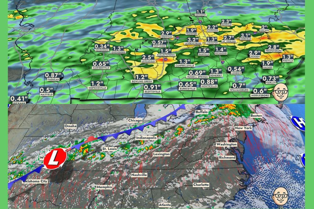
Forecast model guidance valid through Saturday at 12 AM shows a wide spread in projected rainfall totals across Kentucky, with many areas expected to see well under an inch while others see considerably more. Louisville is projected near 2.9 inches, while nearby Frankfort and Cynthiana show totals close to 1.9 and 2.2 inches respectively in the same forecast run.
Farther east, Lexington stands out with a projected total near 3.2 inches, and Morehead shows an even higher projection around 3.1 inches, reinforcing forecaster expectations that the heaviest rainfall will concentrate across the northern and eastern thirds of the state as the system unfolds.
Northern and Eastern Kentucky Face the Highest Totals
Forecasters specifically flagged northern and eastern Kentucky as the areas most likely to see the heaviest rainfall, with the potential for two to three inches or more by the time the system finally clears the region. Communities including Mount Sterling, Maysville, and Jackson all show projected totals exceeding 2.5 inches in the latest model run, with Mount Sterling approaching 2.7 inches and Jackson near 2.9 inches.
By contrast, areas across western Kentucky, including Henderson, Owensboro, and Madisonville, show comparatively lighter totals generally ranging from 0.3 to 1.3 inches, illustrating the sharp west-to-east gradient forecasters expect as the heavier rain bands set up closer to the eastern half of the state.
Forecasters Caution Against Locking In Exact Numbers
Meteorologists emphasized that while the latest model data provides a clearer picture than earlier outlooks, residents should not fixate on the exact rainfall total shown for their specific town, since the heavier rain bands embedded within the broader system are still likely to shift somewhat as the event draws closer. The spread between under an inch in some spots and 2 to 3 inches or more elsewhere highlights just how much local variation is possible with a slow-moving system like this one.
Forecasters noted that this system is the same one they had been highlighting in outlooks issued days earlier, and that the increased detail now available reflects the event coming into much better focus as it approaches rather than a change in the overall forecast philosophy.
Timeline Extends Into the Weekend
With the front’s forward motion slowing considerably, rain chances are expected to persist across parts of Kentucky through Friday night, extending the overall window of unsettled weather well beyond a typical one-day rain event. Radar simulation data valid Thursday at 8:30 AM continues to show widespread coverage lingering across the region as the boundary works through the state.
Residents across Kentucky, particularly in the northern and eastern counties expected to see the heaviest totals, are encouraged to monitor updated forecasts as the week progresses, since the placement of the most intense rain bands remains subject to further refinement as the system approaches.
For continuing coverage of severe weather events and critical storm analysis across the United States, visit svhsnow.com.