RALEIGH, NC — A new day dawned across North Carolina on Saturday with an approaching cold front setting the stage for scattered strong to severe thunderstorms by afternoon and evening, even as the state first endured another round of soaring heat, with highs climbing into the 90s for most areas and heat index values reaching a dangerous 100 to 110-degree range.
Another Scorching Day Before the Front Arrives
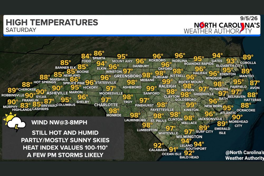
Temperatures Saturday afternoon were forecast to climb well into the 90s across the vast majority of the state under partly to mostly sunny skies, with several cities approaching or reaching the upper end of that range. Fayetteville, Kinston, Sanford, and Clayton were each expected to reach 98 degrees, while Raleigh and Wilson climbed to 97 degrees, and Goldsboro, Wallace, and Jacksonville hit 96 degrees. Even the state’s mountain communities saw unusually warm conditions, with Asheville reaching 90 degrees and Boone hitting 85 degrees, both well above typical highs for higher elevations this time of year.
Cold Front Sets Up Afternoon Storm Threat
The defining feature of Saturday’s forecast is the cold front approaching from the west, which is expected to serve as the trigger for scattered showers and thunderstorms developing from north to south across the state through the afternoon and evening hours. Unlike the isolated, quickly weakening storms seen on previous days, forecasters cautioned that a few of Saturday’s storms could reach strong to severe intensity, specifically citing the potential for damaging winds and large hail as the primary hazards to watch for as the front interacts with the day’s building heat and humidity.
That combination of a strengthening frontal boundary meeting an already hot and humid airmass is a classic recipe for more organized severe weather compared to the random, heat-driven pop-up storms that have characterized much of the state’s recent stretch of hot weather. Residents with outdoor plans Saturday afternoon and evening were specifically urged to remain aware of storms developing around them and to move indoors immediately at the first sound of thunder.
Heat Index Remains Dangerously High
Even with storms in the forecast, the heat itself remains a significant concern across Central and Eastern North Carolina, where heat index values are expected to reach the 100 to 110-degree range despite the approaching front. Cities including Wilmington, New Bern, Greenville, and Elizabeth City are among the areas likely to see the steepest heat index readings, as humidity streaming in ahead of the front compounds the effects of the afternoon sun.
This combination of extreme heat during the day and the potential for severe storms later in the afternoon and evening creates a layered set of hazards for North Carolina residents, requiring both heat safety precautions during the hottest hours and storm awareness as the atmosphere becomes increasingly unstable ahead of the frontal passage.
Storms Developing From North to South
Forecasters indicated the storm activity is expected to initiate first across the northern part of the state before spreading south through the afternoon and evening, giving northern communities the earliest window for potential impacts while southern and coastal areas may not see storm development until later in the day. This progression pattern is typical of a front sweeping through the state from the northwest, gradually triggering instability as it advances southeastward.
Communities across the Piedmont and Coastal Plain, including Greensboro, Durham, Charlotte, and Fayetteville, should watch for the potential for stronger cells as the front approaches during the afternoon hours, while the mountain region may see the front’s effects arrive somewhat earlier given its position farther west.
What Residents Should Do Saturday
With the combination of dangerous heat index values and the potential for severe thunderstorms later in the day, residents across North Carolina are advised to plan outdoor activities around both hazards, avoiding prolonged sun exposure during peak afternoon heat while also staying alert for rapidly developing storms capable of producing damaging winds and large hail as the cold front sweeps through.
Meteorologists will continue tracking the front’s progression closely throughout the day, watching for signs of how quickly storms organize and whether any cells reach the intensity needed to prompt formal severe thunderstorm warnings as the boundary works its way across the state.
For continuing coverage of severe weather events and critical storm analysis across the United States, visit svhsnow.com.