ROCHESTER, MN — Scattered clouds were thinning Monday evening as temperatures held from the mid-60s to the low 70s. More cloud cover is expected overnight, but lows should still stay above normal in the low to mid 60s.
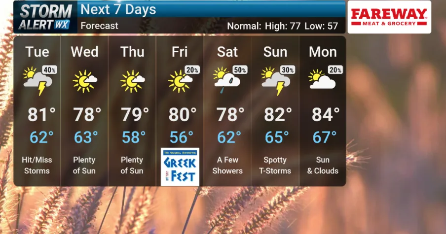
Tuesday is expected to start mostly sunny before clouds build again ahead of a cold front. Forecasters say the day will feel warm and humid, with afternoon highs in the low 80s setting the stage for a more unsettled evening.
What the severe risk looks like
The Storm Prediction Center has outlined a low-end chance for severe storms across the region Tuesday evening. The main concern is isolated storms that could briefly intensify as the front moves through southeast Minnesota and north Iowa.
If a storm does reach severe levels, the biggest hazards would be damaging wind gusts up to 60 mph and hail about the size of quarters. The window for that risk is expected to run from 4 PM to 8 PM Tuesday, and the threat should ease once the front passes.
Forecasters are not calling for widespread severe weather, but they are watching the warm, moist air in place ahead of the boundary closely.
What changes after the front passes
Once Tuesday evening’s front moves east, conditions should calm down. Clouds are expected to clear and northwest winds will strengthen through midweek, bringing a more comfortable feel to the air.
That shift should keep temperatures and dew points in a more tolerable range for a couple of days. The breezier pattern is a notable change from the muggy setup ahead of the front, even if the midweek forecast remains dry for much of the area.
What to watch heading into the weekend
The calmer stretch may not last long. South winds are forecast to return Friday, and with them comes a rise in humidity again.
That will bring higher dew points back into the region and raise the odds for rain and thunderstorms into the weekend. For now, the biggest immediate concern remains Tuesday evening’s narrow severe-weather window before the midweek break arrives.
When the weather turns dangerous, SVH Snow is watching.