SOUTH BEND, IN — The Storm Prediction Center raised the possibility of a new Severe Thunderstorm Watch for Northern Indiana overnight into early Saturday, issuing Mesoscale Discussion #2237 valid until 1:00 AM EDT and assigning a 40 percent watch probability as forecasters monitored the potential for a thunderstorm cluster or better-organized storm complex to develop after midnight.
Uncertainty Remains Over Storm Organization
Forecasters were candid about the uncertainty still surrounding exactly how the developing storm activity would organize overnight. While a thunderstorm cluster or more organized complex remains possible after midnight into the early morning hours, meteorologists indicated that trends observed over the following couple of hours would ultimately determine whether a formal Severe Thunderstorm Watch is actually warranted. That kind of wait-and-see approach is common in overnight severe weather setups, where the atmosphere can either come together to support a more organized threat or fail to fully consolidate.
Damaging Winds Identified as the Primary Hazard
According to the Storm Prediction Center’s discussion, damaging winds stand out as the primary hazard associated with any storms that do develop and organize across the watch area. The most probable peak wind intensity was estimated in the 55 to 70 mph range, strong enough to snap tree limbs, down power lines, and cause scattered property damage across the affected corridor of northern Indiana and the surrounding region.
Hail was also identified as a secondary threat, with the most probable peak hail size estimated at up to 1.25 inches in diameter, roughly the size of a half dollar. While not the primary concern in this setup, hail of that size is capable of causing damage to vehicles, siding, and outdoor property in areas where the stronger, better-organized cells manage to develop.
The Watch Area Stretches Across Northern Indiana
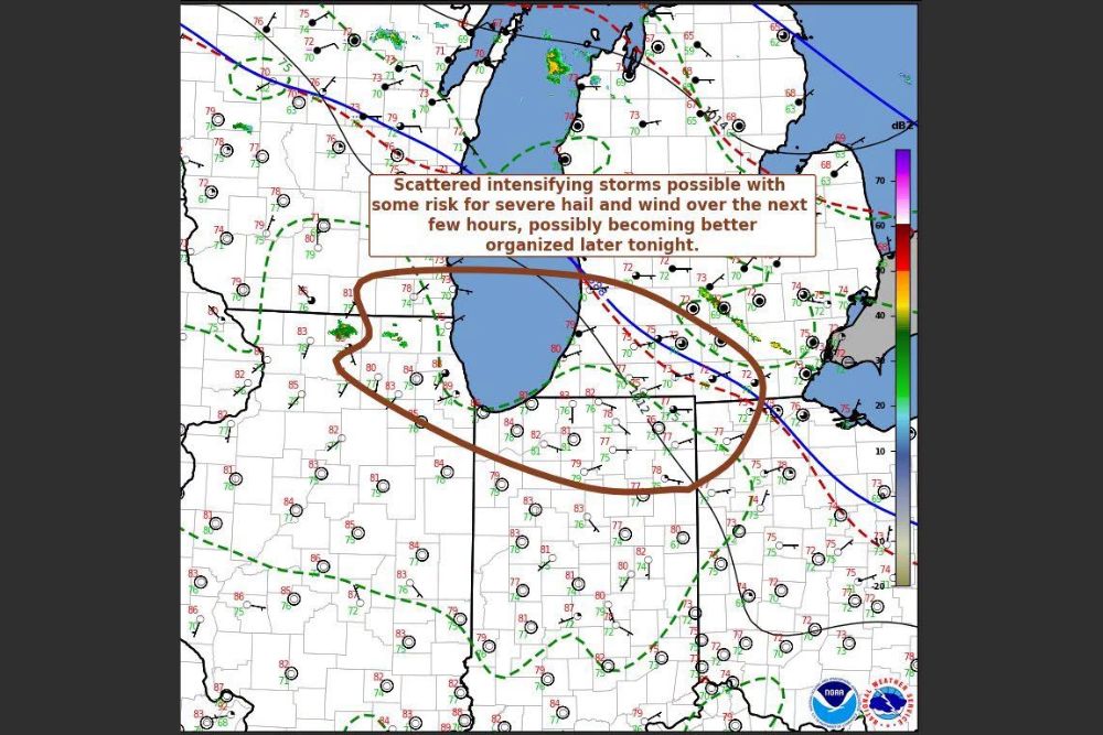
The area outlined in the mesoscale discussion forms a broad corridor arcing across northern Indiana, encompassing communities near South Bend, and extending toward the shores of Lake Michigan before curving back through the broader region bordering southwestern Michigan and the northern Indiana counties. Surface observations plotted on the discussion map showed warm, humid conditions in place across the watch area, with dewpoints and temperatures in the upper 70s to lower 80s in many locations, providing ample fuel for storms to intensify once they begin to organize.
The presence of a warm front, marked in red, draped near the Michigan-Indiana border, combined with an approaching cold front visible farther west, created the kind of boundary interaction that forecasters watch closely for triggering scattered but potentially intensifying storms overnight, particularly as those boundaries continue to interact with the very warm and moist air mass already in place.
Why Overnight Severe Weather Requires Extra Caution
Severe thunderstorms that develop or intensify overnight carry heightened risk for residents who may already be asleep and less likely to receive immediate warning of rapidly changing conditions. This makes it especially important for anyone within the highlighted corridor across northern Indiana to have a reliable way of receiving emergency alerts overnight, whether through a NOAA weather radio or a mobile device with wireless emergency alerts enabled, given the potential for winds capable of causing damage even without a tornado threat present.
The Storm Prediction Center’s mesoscale discussion process exists specifically to bridge the gap between broader daily outlooks and the more immediate, higher-confidence warnings issued by local National Weather Service offices, allowing forecasters to flag a specific area of concern hours in advance while the finer details of storm organization continue to come into focus.
What Comes Next for Northern Indiana
With the watch probability sitting at 40 percent, forecasters are essentially indicating better than even odds against a formal watch being issued at this stage, though that figure remains subject to change quickly based on how the atmosphere evolves through the overnight hours. Should storms show clear signs of organizing into a more cohesive cluster or line with sustained damaging wind potential, a Severe Thunderstorm Watch could be issued for the region with relatively short notice.
Residents across northern Indiana and the surrounding areas are advised to stay tuned to updated forecasts through the overnight hours, keep phones charged and alerts enabled, and be prepared to move to safe shelter quickly should a warning be issued for their specific location as the situation continues to develop.
For continuing coverage of severe weather events and critical storm analysis across the United States, visit svhsnow.com.