LITTLE ROCK, AR — Arkansas is set to close out the week with a modest chance for rain, as forecast models show scattered showers and storms developing Thursday into Friday across much of the state. While model data has hinted at more widespread coverage, meteorologists say the realistic outlook boils down to a 10 to 30 percent chance of rain, with the potential for a few pockets of heavier downpours mixed among mostly dry conditions.
Scattered Storms Expected Thursday Afternoon
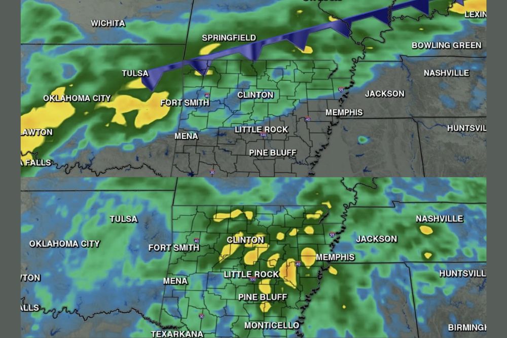
Forecast guidance shows rain chances beginning to build across northern and western Arkansas by Thursday at midday, with scattered activity stretching from the Fort Smith and Clinton areas eastward toward Little Rock and Pine Bluff later in the day. The overall coverage is expected to remain limited, with most of the state staying dry even as isolated cells produce brief, heavier rainfall.
Communities including Mena, Texarkana, and Monticello are also within the broader area where scattered storms could develop, though coverage is expected to be inconsistent rather than a widespread soaking rain event. Forecasters emphasized that while the visual coverage on model radar simulations can appear extensive, actual rainfall will likely be confined to scattered cells rather than a solid line of steady rain.
Friday Brings a Slightly Better Coverage of Showers
By Friday afternoon, forecast trends suggest slightly better organization to the scattered storms, with activity again focusing on the Little Rock, Clinton, and Pine Bluff corridor before shifting toward areas near Texarkana and points south by early evening. Isolated heavier downpours remain possible within the scattered coverage, particularly where storms can briefly train over the same location.
Despite the modest rain chances, the timing lines up well with an expected shift in temperatures, as the arrival of scattered convection is forecast to help temperatures ease during the afternoon hours on Friday after several days of well-above-normal heat across the region.
Highs Reach the Low 90s Before Any Relief Arrives
Ahead of Friday’s scattered rain chances, Arkansas will continue to see summer-like heat, with afternoon highs reaching the low 90s across much of the state. Forecast temperature guidance shows readings near 93 degrees in Little Rock, 92 degrees in Hot Springs and Stuttgart, and highs as warm as 95 degrees in De Queen and Texarkana by Friday afternoon.
Even typically cooler higher-elevation communities like Harrison and Mountain Home are forecast to see highs in the upper 70s to mid-80s, reflecting how widespread the late-week warmth will be before any cooling trend associated with Friday’s rain chances takes hold across the region.
Looking Ahead to the Weekend
Forecasters indicated that the combination of scattered rain and any associated cloud cover on Friday should help nudge temperatures down from the oppressive levels seen earlier in the week, offering a modest but welcome break from the heat heading into the weekend. Areas that manage to see rainfall, even brief, are likely to notice the most noticeable cooling effect compared to spots that stay dry.
Residents across Arkansas are encouraged to keep an eye on updated forecasts as Thursday and Friday approach, since scattered coverage events like this one can shift in timing and placement as models converge closer to the event. The overall pattern points toward a drier end to the week than model data might initially suggest, with any relief from the heat likely tied directly to which areas manage to catch a passing shower.
For continuing coverage of severe weather events and critical storm analysis across the United States, visit svhsnow.com.