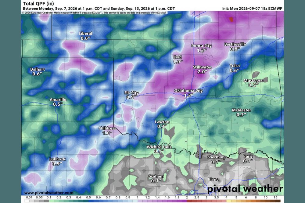
OKLAHOMA CITY, OK — A much-needed pattern change is taking shape across Oklahoma and the Texas Panhandle, with a new ECMWF forecast model showing meaningful rainfall totals building across the region between Monday, September 7 and Sunday, September 13. The forecast outlines two distinct rounds of precipitation, one arriving late this week and a second developing early next week, with Stillwater projected to see the highest totals in the outlook at roughly 2.0 inches.
First Round of Rain Arrives Thursday Into Friday
The initial round of rainfall is expected to move through the region Thursday into Friday, bringing widespread but variable totals across Oklahoma and portions of the Texas Panhandle. Forecast guidance shows Ponca City picking up around 1.2 inches, while Oklahoma City is projected to see approximately 1.3 inches during the overall six-day window covered by the model.
Farther west, totals taper off but remain meaningful for a region that has been watching for rain, with Elk City projected near 0.9 inches and Amarillo expected to receive close to 0.5 inches. The Texas Panhandle communities of Dalhart and Lubbock are also included in the forecast swath, with Dalhart projected at 0.6 inches and Lubbock near 0.9 inches by the end of the forecast period.
Second Round Targets the Region Monday Into Tuesday
Following a brief lull, forecast models indicate a second round of precipitation developing and moving through the region around Monday and Tuesday of the following week. This second wave is expected to reinforce totals already accumulated from the Thursday-Friday system, particularly across north-central Oklahoma, where the heaviest rainfall in the entire outlook is concentrated.
Stillwater stands out in the forecast data with a projected total near 2.0 inches, the highest single-location total shown across the entire map, suggesting that area could see the most consistent and significant rainfall from both rounds combined. Nearby Enid is also forecast to pick up close to 1.0 inch, reinforcing the idea that north-central Oklahoma will be a focal point for this multi-day rain event.
Forecast Confidence and the Potential for Shifts
Meteorologists tracking the pattern have cautioned that while the overall signal for rain is encouraging, the exact placement and timing of both rounds remains subject to change as the forecast period approaches. Medium-range models like the ECMWF are valuable for identifying broader trends in precipitation potential, but day-to-day totals and the exact axis of heaviest rain often shift as shorter-range models come into better agreement closer to the event.
Areas farther south and east, including Wichita Falls, Sherman, and Paris, are shown with comparatively lighter totals near 0.1 inches, illustrating how sharply rainfall amounts can vary across a relatively short distance within the same forecast system. That gradient underscores why continued monitoring will be necessary as both rounds of rain approach.
What Residents Across the Region Should Expect
For a region that has been closely watching the skies, the forecast represents a potentially welcome shift toward wetter conditions spanning the back half of this week and into the middle of next week. Communities from the Texas Panhandle through north-central Oklahoma and into northeastern Oklahoma cities like Bartlesville and Tulsa, projected near 0.8 inches and 0.6 inches respectively, are all included within the broader forecast swath.
Residents are encouraged to continue monitoring updated forecasts as the week progresses, since the placement of both rounds could still shift before the rain arrives. The six-day outlook offers an early look at a pattern that, if it verifies as modeled, would bring beneficial rainfall to a wide stretch of the southern Plains.
For continuing coverage of severe weather events and critical storm analysis across the United States, visit svhsnow.com.