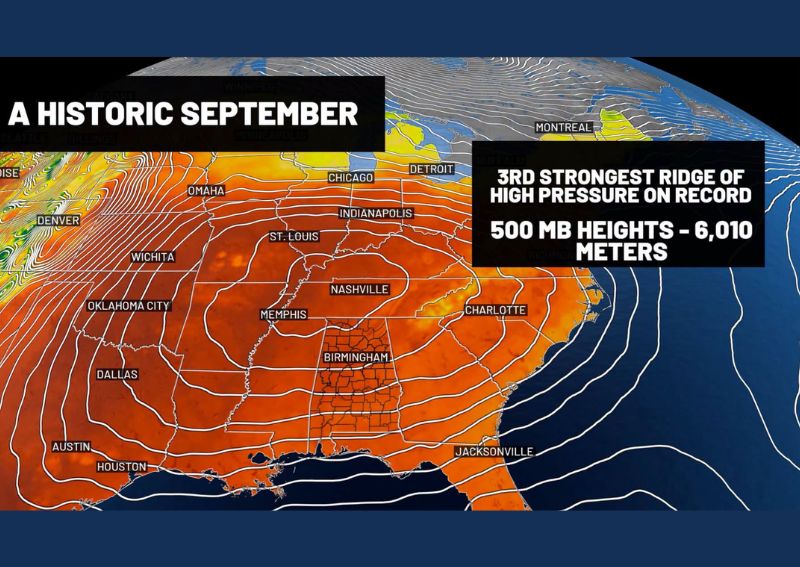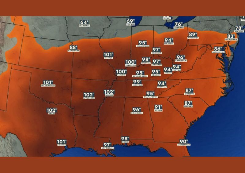
LOUISVILLE, KY — As the calendar heads into the second half of September, oppressive summer-like heat is showing no signs of easing across Kentucky and much of the South, with Wednesday afternoon’s heat index expected to reach around 100 degrees in Paducah, 98 degrees in Louisville, and 95 degrees in Bowling Green. The muggy, uncomfortable heat is forecast to hang around through both Thursday and Friday, keeping the region locked in conditions that feel far more like peak summer than approaching fall.
Wednesday Brings Widespread Triple-Digit Heat Index Values
Heat index forecast data for Wednesday at 3:30 PM shows an enormous swath of the central and southern United States experiencing heat index readings in the 90s and low 100s, with some of the most extreme values concentrated across the Mid-South and Southern Plains. Little Rock and Memphis are both projected to see heat index readings of 102 degrees, matching Dallas at the same triple-digit mark.
Across Kentucky specifically, St. Louis-adjacent areas near Evansville are forecast at 100 degrees, while Lexington comes in at 97 degrees and Somerset and Hazard both reach the mid-90s, illustrating just how widespread the oppressive heat has become across the entire commonwealth.
Jackson and Surrounding Areas Also Face Mid-90s Heat
The outlook specifically highlighted mid-90s heat index values around Jackson, placing that area within the broader zone of dangerous, summer-like conditions affecting much of the eastern Kentucky region. Nearby communities including Pikeville are forecast to see similar readings in the 94-degree range, reflecting how consistently the heat is blanketing eastern Kentucky alongside the rest of the state.
This widespread heat coverage across both western and eastern Kentucky underscores that no part of the state is being spared from this stretch of unusually intense, late-season warmth, even as the calendar moves further into what should typically be a transitional period toward cooler fall weather.
Historical Averages Show Just How Abnormal This Heat Is
Forecasters offered important perspective by comparing this week’s expected heat to typical seasonal norms, noting that by September 16, normal high temperatures are only about 83 degrees in Paducah, 82 degrees in Louisville, and 83 degrees in Bowling Green. Jackson’s average high for September 16 sits at just 79 degrees, making this week’s forecast heat index values of 95 to 100 degrees an enormous departure from what residents would typically expect at this point in September.
This stark contrast between forecast conditions and historical averages, often exceeding normal highs by 15 to 20 degrees once heat index is factored in, illustrates just how significantly this stretch of weather deviates from what Kentucky residents would consider typical mid-September conditions.
Muggy Heat Persists Through Thursday and Friday
Rather than offering a brief, one-day spike in heat, forecast data shows this oppressive pattern continuing through both Thursday and Friday, with heat index values remaining in a similar 90s to low 100s range across much of the same affected region. Thursday’s forecast shows continued triple-digit readings across portions of Arkansas, Mississippi, and Louisiana, with Kentucky communities remaining in the high 90s to around 100 degrees.
Friday’s outlook shows a nearly identical pattern persisting, with Memphis again reaching 102 degrees and Kentucky cities holding steady in the mid-to-upper 90s, confirming that this is a multi-day heat event rather than a brief, isolated spike in temperatures.
Scattered Storms May Offer Limited Relief
Forecasters noted that a few small cool zones could develop as scattered showers and thunderstorms form across parts of the region during this stretch, offering brief, localized relief from the oppressive heat and humidity. However, they were direct in cautioning residents not to count on these scattered storms for any meaningful or widespread relief from the overall pattern.
This caveat is important for residents hoping for a genuine break in the heat, since isolated storm activity typically provides only temporary and geographically limited cooling, rather than the kind of broader pattern change needed to bring lasting relief across the entire affected region.
Feels Like July, Not Mid-September
Forecasters summarized the situation bluntly, noting that while the calendar indicates the region is closing in on fall, conditions will continue to feel a whole lot like July rather than mid-September. This characterization captures just how significantly this stretch of weather is out of step with the seasonal transition residents would typically expect to be experiencing at this point in the calendar.
For a region accustomed to seeing at least some early hints of cooler fall weather by mid-September, this extended stretch of summer-like heat and humidity represents a notable and uncomfortable departure from typical seasonal expectations across Kentucky and the broader South.
What Residents Should Expect
Residents across Kentucky and the broader South, from Paducah and Louisville to Jackson and Bowling Green, should prepare for continued oppressive, muggy heat with index values reaching the 90s to low 100s through at least Friday. Given the limited and unreliable nature of any relief from scattered storms, residents should continue taking heat safety precautions throughout this extended stretch of summer-like conditions.
For continuing coverage of severe weather events and critical storm analysis across the United States, visit svhsnow.com.