PORTLAND, ME — A cooler and drier air mass settling into northern New England on Monday night is setting the stage for areas of frost by early Tuesday morning, particularly across the colder valleys and sheltered interior locations of Maine, New Hampshire, and Vermont. Forecasters describe this as a legitimate early-season frost opportunity, with the coldest valleys and sheltered spots having the best chance for frost development between the pre-dawn hours and sunrise on Tuesday.
Strong Overnight Cooling Sets the Stage
The setup favors strong overnight cooling as clearing skies, lighter winds, and the incoming cooler air mass combine to allow temperatures to fall quickly after sunset on Monday night. Forecasters indicated that some of the traditional cold spots across the region could drop into the mid and upper 30s, with the coldest valleys potentially reaching the lower 30s by early Tuesday morning.
This combination of clear skies and calm winds represents an ideal setup for radiational cooling, a process where the ground and surrounding air lose heat efficiently overnight without cloud cover or wind to trap or mix warmer air back toward the surface, allowing temperatures to drop more dramatically than they otherwise would.
Northern and Interior Maine Face the Greatest Risk
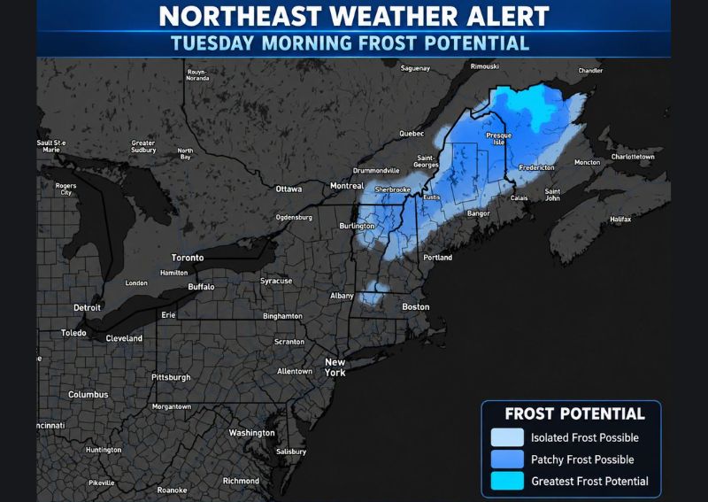
Forecast mapping shows the greatest frost potential concentrated across northern and interior Maine, particularly in the area surrounding Presque Isle, where the darkest blue shading on the frost potential map indicates the highest likelihood of frost development. This region’s combination of northern latitude and interior positioning, away from the moderating influence of the coast, makes it especially susceptible to the kind of rapid overnight cooling expected with Monday night’s air mass.
The colder valleys of northern New Hampshire and Vermont are also highlighted as facing meaningful frost potential, extending the zone of greatest concern westward from Maine across the northern tier of the broader New England region.
Patchy Frost Possible Into the Adirondacks
Beyond the primary zone of greatest concern, forecasters noted that patchier frost may also extend into portions of the Adirondacks and other favored low-lying areas farther west, based on the frost potential mapping that shows a corridor of patchy frost possible conditions stretching from northern New England into eastern New York. This broader reach suggests the cooler air mass responsible for Tuesday morning’s frost potential extends across a fairly wide geographic area beyond the immediate northern New England core.
Communities in these more westward, patchy frost zones should still take the potential seriously, even though their overall risk level remains lower than the areas of greatest frost potential concentrated across northern Maine and the colder valleys farther south.
Coastal Areas and Southern New England Expected to Stay Milder
Forecasters were clear that this setup does not represent a widespread hard freeze for all of New England, with coastal areas, larger cities, and much of southern New England expected to remain milder overnight. This distinction is important for residents across the more populated southern and coastal portions of the region, who should not expect the same frost risk facing the colder interior valleys farther north.
The moderating influence of the ocean along the coast, combined with the urban heat retained by larger cities, typically prevents the kind of rapid, dramatic overnight cooling needed for frost formation, even when the broader regional air mass turns notably cooler and drier as expected Monday night.
Frost Can Form Even Above 32 Degrees
Forecasters offered an important educational point, noting that air temperature does not always need to reach exactly 32°F for frost to actually form. On a clear, calm night, surfaces near the ground can cool several degrees below the measured air temperature, meaning frost can develop even when nearby official readings still show the mid-to-upper 30s.
This distinction helps explain why frost can sometimes catch residents off guard even when forecast low temperatures appear to stay just above freezing, since the specific microclimate conditions near the ground, particularly in sheltered, low-lying areas, can produce frost-favorable surface temperatures even under those seemingly marginal air temperature readings.
Residents With Sensitive Plants Should Take Precautions
Given the legitimate frost potential across northern New England, forecasters specifically advised anyone with sensitive plants in the affected region to take precautions on Monday evening ahead of the overnight cooling. This proactive recommendation reflects the genuine risk this setup poses to frost-sensitive vegetation, particularly in the colder valley locations where the greatest frost potential has been identified.
Taking steps such as covering sensitive plants or bringing potted vegetation indoors ahead of Monday night’s cooling could help prevent damage for gardeners and residents across the highlighted frost potential zones, especially given how early in the fall season this particular frost opportunity is developing.
What Residents Should Expect
Residents across northern and interior Maine, along with the colder valleys of northern New Hampshire and Vermont, should prepare for a legitimate chance of frost developing during the pre-dawn hours into Tuesday morning, with the coldest, most sheltered locations facing the highest risk. Those in coastal areas, larger cities, and southern New England can expect to remain milder and should not anticipate the same frost concerns affecting the northern interior of the region.
For continuing coverage of severe weather events and critical storm analysis across the United States, visit svhsnow.com.