DAYTON, OH — It was feast or famine on rainfall across the region over the last 24 hours, with select corridors seeing extremely high totals while other areas saw not much at all. Forecast data shows several distinct bands stretching from Celina through Dayton and Richmond, some capturing 2 to 4 inches or more, illustrating just how unevenly this rain event distributed across western Ohio.
A Sharp Corridor of Heavy Rain Near Celina
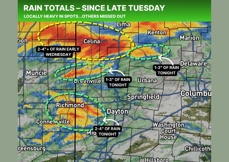
Radar data highlights a well-defined corridor stretching from near Muncie through Celina and toward Lima, where 2 to 4 inches or more of rain fell early Wednesday. This band, outlined in yellow on the rainfall totals map, shows the classic hallmark of a training thunderstorm setup, where repeated rounds of heavy rain track over nearly the same path, dramatically boosting totals within a relatively narrow strip.
The intensity visible on radar within this corridor, shown in deep red and orange coloring, reflects sustained heavy rainfall rather than a single brief downpour, consistent with the kind of locally significant totals forecasters described for this particular band.
A Second Band Targets Greenville Through Urbana
A second highlighted corridor, marked in green, stretches from near Greenville eastward through Urbana and toward Delaware, where 1 to 3 inches of rain fell tonight. This band sits just south of the more intense Celina corridor, illustrating how closely spaced these distinct rainfall zones became despite their notably different totals.
The proximity of this moderate corridor to the more extreme rainfall just to its north underscores exactly the kind of complex, uneven distribution forecasters were highlighting, since communities just a short distance apart experienced meaningfully different rainfall outcomes from what was fundamentally the same overall weather system.
Richmond to Dayton Corridor Sees the Heaviest Totals Tonight
A third distinct band, stretching from near Richmond and Connersville through Dayton, recorded some of the heaviest tonight’s totals at 2 to 4 inches. This corridor represents another example of the concentrated, locally intense rainfall that characterized this event, with Dayton itself falling within the zone experiencing the higher end of tonight’s rainfall range.
Communities along this corridor should expect the kind of potential localized flooding concerns that typically accompany rainfall totals in this range, particularly in low-lying areas or locations with limited drainage capacity following such a concentrated rain event.
Some Areas Missed Out Almost Entirely
In sharp contrast to these heavy rainfall corridors, forecasters noted that some areas saw not much rain at all during the same 24-hour period, with one local report citing less than a quarter inch measured between morning and tonight. This stark difference between the heaviest corridors and the areas that missed out entirely captures the essence of the feast or famine characterization used to describe this event.
This kind of dramatic variation, even within a relatively compact geographic area, highlights how individual storm cells and rain bands can produce vastly different outcomes for communities located only a short distance apart from one another.
Why Rainfall Forecasting Can Be So Complex
Forecasters used this event as a real-world example of how forecasting rainfall can be complex, noting that some locations get nailed by these kinds of patterns while totals usually never fall evenly across an entire region during setups like this one. This kind of narrow-band rainfall variability represents one of the more challenging aspects of precipitation forecasting, since predicting the exact placement of the heaviest bands, sometimes just a matter of a few miles from areas that stay largely dry, remains difficult even with modern forecasting tools.
This educational framing helps residents understand why forecast rainfall totals for their specific location can sometimes differ significantly from what actually falls, particularly during setups involving slow-moving or training thunderstorm activity like the one responsible for tonight’s uneven distribution.
Feast or Famine: Which Side Were You On?
Given the dramatic variation in rainfall totals across the region tonight, some residents likely experienced significant, potentially beneficial rainfall while others just a short distance away saw very little change from dry conditions. This kind of localized contrast is a common feature of rainfall events driven by narrow, slow-moving bands rather than a broad, uniform area of steady rain.
What Residents Should Expect
Residents across the corridor stretching from Celina through Dayton and Richmond should be aware that recent rainfall in their specific area may have been significantly heavier or lighter than nearby communities, given the uneven nature of this event. Those in areas that received the heavier 2 to 4 inch totals should remain alert for potential localized flooding or drainage issues following such a concentrated rain event.
For continuing coverage of severe weather events and critical storm analysis across the United States, visit svhsnow.com.