DES MOINES, IA — Conditions are strongly expected to support an all-hazard severe weather event, including the potential for tornadoes, across western Iowa and eastern Nebraska on Friday afternoon and evening, according to the latest forecast analysis. Forecasters noted that while uncertainties remain regarding storm initiation, the underlying atmospheric setup is favorable enough for a legitimately significant severe weather threat to develop.
Extreme Instability Builds Across the Region
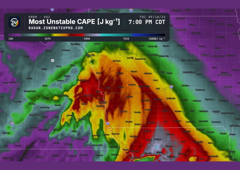
Forecast data showing Most Unstable CAPE, a key measure of atmospheric instability, valid for 7:00 PM CDT Friday, September 18, reveals an enormous area of extreme instability stretching across western Iowa and into eastern Nebraska. The darkest red shading on the map, indicating values approaching the highest end of the scale, is concentrated in a corridor running from near Omaha through Des Moines and extending southeast toward Ottumwa.
This kind of widespread, intense instability represents one of the key ingredients necessary for significant severe weather, including the potential for strong to violent thunderstorms capable of producing tornadoes, provided the other atmospheric ingredients also come together as forecast.
The Missing Ingredient: Upper-Level Support
Despite the abundant instability in place, forecasters identified the one main ingredient currently missing from this setup as upper-level support, also referred to as forcing, which lowers overall confidence in exactly how storms will develop. Upper-level support typically refers to features in the upper atmosphere that help trigger and organize thunderstorm development, and its absence introduces genuine uncertainty about whether storms will initiate as robustly as the instability alone would suggest.
This gap between an otherwise favorable environment and the lack of a clear triggering mechanism is a common source of forecast uncertainty in severe weather situations, since abundant instability without adequate forcing can sometimes result in fewer storms developing than the raw atmospheric ingredients might otherwise support.
Regardless of Uncertainty, Conditions Strongly Support Severe Weather
Despite the uncertainty surrounding storm initiation, forecasters were clear that conditions will strongly support an all-hazard severe weather event regardless of exactly how storms end up forming. This distinction is important, since it means that even with some question marks about the triggering mechanism, the broader environment remains primed for significant severe weather impacts if and when storms do develop across the highlighted region.
An all-hazard designation typically signals that forecasters see potential for multiple types of severe weather simultaneously, including damaging winds, large hail, and tornadoes, rather than the threat being dominated by just one specific hazard type.
Tornado Potential Specifically Highlighted for Friday
Forecasters specifically flagged the potential for tornadoes during Friday afternoon and evening across western Iowa and eastern Nebraska, representing the most serious individual hazard within this broader all-hazard outlook. The combination of the extreme instability shown on the CAPE mapping with sufficient wind shear, if present, would create conditions conducive to rotating supercell thunderstorms capable of producing tornadoes.
Communities across the highlighted corridor, including areas surrounding Omaha, Council Bluffs, and Des Moines, should take this tornado potential seriously given how favorable the broader atmospheric setup appears for this time of year and this stage of the forecast.
Trends Could Push the Threat Higher
Forecasters indicated they will continue watching further trends in the data, noting that if the chances of storm development increase in subsequent forecast updates, the overall severe weather threat could shift toward the higher end of the spectrum. This kind of conditional outlook reflects how closely tied the ultimate severity of Friday’s event is to whether that missing upper-level support materializes or whether some other triggering mechanism helps storms initiate more robustly than currently expected.
This forward-looking caveat suggests residents across the affected region should continue monitoring updated forecasts as Friday approaches, since the threat level could evolve in either direction depending on how the atmospheric setup continues to develop over the coming days.
A Serious Setup Despite the Uncertainty
The scale of instability shown in Friday’s forecast data, combined with the specific mention of tornado potential and the all-hazard framing, indicates forecasters are treating this as a genuinely serious potential severe weather setup for the region. Even with the acknowledged uncertainty about storm initiation, the underlying ingredients present a scenario that warrants close attention and preparation from residents across western Iowa and eastern Nebraska.
What Residents Should Do to Prepare
Given the potential for an all-hazard severe weather event, including tornadoes, residents across western Iowa and eastern Nebraska should use the time before Friday afternoon to review severe weather safety plans and ensure reliable access to warnings. With forecasters indicating the threat level could increase depending on how trends develop, continued monitoring of updated forecasts will be essential as the timeframe approaches.
For continuing coverage of severe weather events and critical storm analysis across the United States, visit svhsnow.com.