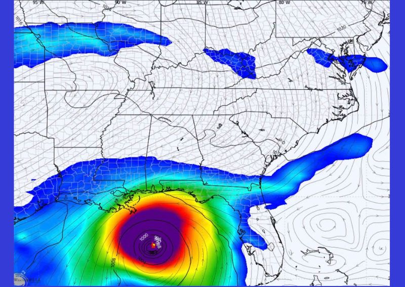
NEW ORLEANS, LA — The latest GFS model run is showing a well-organized area of low pressure developing in the Gulf of Mexico around September 25th, with forecast data depicting the disturbance wound tightly enough to display numerous pressure lines wrapped around its center. Forecasters were quick to stress that this represents just one model run at extended range, not a confirmed forecast, and that the eventual outcome for this feature remains entirely unknown at this stage.
A Tightly Wound Low Pressure Signal Appears in the Gulf
The model output shows an area of low pressure centered in the central Gulf of Mexico, with a minimum pressure reading near 1000 millibars and multiple tightly spaced isobars, the pressure lines used to depict a storm’s intensity and structure, wrapping around the system’s center. This kind of tightly wound pressure pattern in model data typically indicates the model is depicting a fairly well-organized and potentially strengthening low-pressure system.
The map also shows a broader area of disturbed weather and elevated moisture stretching from the western Gulf Coast near Louisiana and Mississippi across the Southeast and into portions of the Mid-Atlantic and Northeast, suggesting this system’s associated moisture footprint could extend well beyond the immediate Gulf region if it develops as depicted.
This Is One Model Run, Not a Forecast
Forecasters were emphatic in framing this appropriately: this is September 25th, from one GFS model run, and it does not constitute an actual forecast for what will happen on that date. At this range, more than a week and a half out, forecast models routinely show features that later shift dramatically in position, change substantially in character, or fail to materialize at all once the forecast window shortens and more reliable data becomes available.
That caveat is especially important for a system depicted in the Gulf of Mexico, given the region’s history of rapid development and intensification, making it particularly important that any early model signal be communicated with appropriate uncertainty rather than treated as a settled outcome.
The System Could Become Nearly Anything
Meteorologists tracking this signal noted that at this range, the feature currently shown could become a hurricane, a disorganized area of rain, get absorbed by an approaching cold front, or disappear from model guidance entirely as new data comes in. This wide range of possible outcomes reflects just how much uncertainty remains in long-range tropical forecasting, particularly for a system that has not yet actually formed.
This kind of broad uncertainty is a standard feature of extended-range model output, since the atmosphere’s chaotic nature means small differences in initial conditions can produce dramatically different outcomes by the time a forecast reaches ten or more days into the future.
Gulf Coast States Fall Within the Broader Area of Interest
The model’s disturbed weather pattern touches on states across the Gulf Coast, including Louisiana, Mississippi, and the Florida Panhandle, before the broader moisture plume extends into the Florida Peninsula and up the Eastern Seaboard. This wide geographic footprint in the current model run means residents across a substantial portion of the Southeast and Gulf Coast could see some connection to this system if it verifies in any form.
Given how much uncertainty remains regarding the system’s eventual track, strength, or even whether it develops at all, this broad area of potential interest should be understood as a reflection of one model’s current output rather than a defined warning area for any specific location.
Why the Signal Still Gets Attention Despite the Uncertainty
Even with all these caveats, forecasters continue to highlight signals like this one because the tightly organized pressure pattern shown in the model does represent a legitimate feature worth watching as the date approaches. Flagging a signal like this early gives the public a heads-up that an area of interest exists, without requiring anyone to take dramatic action based on a single, distant model run.
This approach reflects a broader philosophy in tropical forecasting: watch persistent trends across many model runs over multiple days, rather than reacting strongly to any single run’s specific depiction, especially one occurring more than a week and a half into the future.
No Reason for Alarm or Preparation at This Stage
Forecasters were direct that this current signal does not warrant panic buying, evacuation planning, or any other significant preparation response at this point. The appropriate response is simply continued awareness of the date and general area, rather than any specific action, given how much can change between now and September 25th as additional, more reliable model runs become available.
This measured approach is particularly important given how quickly speculation can spread when a single dramatic-looking model image circulates, even when the underlying data carries the significant uncertainty inherent to any forecast at this range.
What Comes Next
As September 25th approaches, forecasters will continue monitoring whether this signal persists across additional model runs, strengthens in confidence, or fades entirely as the forecast period moves from the extended range into more reliable short and medium-range guidance. Residents along the Gulf Coast and Southeast are encouraged to remain generally aware of this developing conversation without treating the current one-run signal as an actionable forecast for any specific storm.
For continuing coverage of severe weather events and critical storm analysis across the United States, visit svhsnow.com.