LEXINGTON, KY — A stubborn ridge of high pressure responsible for Kentucky’s September heat isn’t going anywhere fast, with forecasters saying there’s very little change in the overall setup Thursday into Friday, keeping the state firmly on the warm side of things. Anyone hoping for a big push of fall air will have to keep looking, since summer isn’t ready to give up just yet.
The Ridge Refuses to Budge
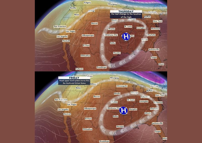
Forecast mapping for Thursday at 2:00 PM shows almost no real change to the location of the high-pressure ridge centered over the Mid-South, with the “H” marker sitting in nearly the same position as it has for days. That persistence is the core reason Kentucky remains locked into an unseasonably warm pattern, since a ridge this entrenched effectively blocks any cooler air from making meaningful progress into the region.
Communities across the state, including Lexington, Louisville, and Bowling Green, all fall within the broad dome of warm air this ridge continues to protect, keeping temperatures elevated well above what would be typical for mid-September.
A Weak System Passes Through the Northwest, But Not Here
By Friday at 2:00 PM, forecast data shows a weak upper-level system moving through the Northwest United States, visible as a band of disturbed weather stretching from the Pacific into the northern Rockies. While this system represents some degree of pattern change on the broader map, forecasters were clear it isn’t strong enough to break down the ridge sitting over Kentucky’s part of the country.
This distinction matters because a weak, far-removed system passing through a completely different region of the country does little to disrupt a well-established ridge holding firm over the Ohio Valley and Mid-South, leaving Kentucky’s warm pattern essentially untouched by that Friday disturbance.
Bottom Line: The Heat Holds On
Forecasters summed up the outlook bluntly: the heat holds on, and summer isn’t ready to give up just yet. That assessment reflects both days’ map data showing the ridge maintaining its grip on the region with no meaningful erosion in strength or position between Thursday and Friday.
For a state typically expecting at least some hint of cooling by this point in September, this continued heat represents an extended departure from seasonal norms, with no immediate relief showing up in the short-range forecast data.
Eventually This Pattern Will Break, Just Not Yet
Looking further ahead, forecasters offered a note of eventual optimism, acknowledging that this pattern will break at some point, but stressed that current maps simply don’t support that happening anytime soon. This kind of caveat is common when a ridge has proven this persistent, since even meteorologists tracking the pattern day to day can only say with confidence what the maps show through the next couple of days.
That framing suggests Kentucky residents should not expect a specific date for relief just yet, but should instead understand that the current stretch of warmth is a temporary, if stubborn, feature rather than a permanent seasonal shift.
What Residents Should Expect
Residents across Kentucky should prepare for continued warm conditions through both Thursday and Friday, with the ridge responsible for the state’s September heat showing no signs of relocating or weakening during that window. The weak system passing through the Northwest on Friday will have no meaningful impact on Kentucky’s pattern, meaning residents should continue expecting summer-like warmth rather than any early taste of fall.
For continuing coverage of severe weather events and critical storm analysis across the United States, visit svhsnow.com.