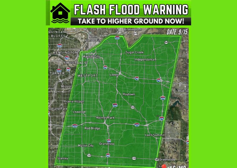
KANSAS CITY, MO — A Flash Flood Warning has been issued for the Kansas City metro area on September 15, with Doppler radar indicating thunderstorms producing heavy rain across a broad warned zone that includes Kansas City, Independence, Raytown, Lee’s Summit, Grandview, Leawood, Prairie Village, Mission, Westport, Sugar Creek, and surrounding areas. Officials warn that between 0.5 and 2.5 inches of rain has already fallen, with another 0.5 to 2.5 inches possible, as flash flooding is either ongoing or could begin shortly.
Warning Covers a Wide Swath of the Metro Area
The warning polygon stretches from North Kansas City and Sugar Creek in the north down through Westport, Raytown, and Leawood in the central portion of the metro, continuing south to encompass Grandview, Lee’s Summit, and Greenwood near the warning’s southern boundary. This extensive coverage area spans both the Missouri and Kansas sides of the metro, illustrated by the KS/MO designation marking the warning’s geographic scope.
The shape of the warning area, elongated in a roughly north-south orientation, suggests the heaviest rain-producing storms have tracked along a similar path, delivering repeated or sustained heavy rainfall to communities positioned along that particular corridor through the heart of the metro.
Substantial Rainfall Already Recorded
Radar-estimated rainfall data indicates that between 0.5 and 2.5 inches of rain has already fallen across portions of the warned area, a substantial range that reflects the variability in rainfall intensity across different parts of the metro. This already-significant accumulation sets the stage for potential flooding concerns even before accounting for any additional rainfall expected to fall.
Communities toward the higher end of that recorded range would have already experienced meaningful rainfall totals capable of producing localized flooding, particularly in areas with poor drainage or those situated near smaller creeks and streams that can rise quickly during periods of intense rainfall.
Additional Heavy Rain Remains Possible
Beyond what has already fallen, forecasters indicated that another 0.5 to 2.5 inches of rain remains possible across the warned area, meaning total rainfall from this event could potentially reach as high as 5 inches in the hardest-hit locations once all the rain has moved through. This combination of already-substantial rainfall and continued heavy rain potential is precisely why the Flash Flood Warning remains active across such a wide portion of the metro.
The possibility of additional heavy rainfall on top of what has already accumulated significantly raises the risk of more serious flooding impacts, particularly if the heaviest bands continue tracking over the same areas that have already received substantial rain.
Flash Flooding Is Ongoing or Imminent
Officials were direct in their assessment that flash flooding is either ongoing or could begin shortly across the warned area, reflecting the serious and immediate nature of this weather threat. This language indicates forecasters have high confidence that flooding impacts are either already occurring or are very likely to develop imminently given current radar-observed rainfall rates.
Given this assessment, residents throughout the warned zone should treat the flooding threat as an active, developing emergency rather than a distant or hypothetical concern, particularly in low-lying areas and locations near creeks, streams, or other drainage features prone to rapid rises during heavy rainfall events.
Move to Higher Ground and Avoid Flooded Roads
Officials issued a direct safety message to residents within the warned area: move to higher ground and never drive through flooded roads. This combination of instructions addresses both the immediate danger to anyone in low-lying areas susceptible to rising water and the well-documented risk associated with attempting to drive through flooded roadways, which remains one of the leading causes of flood-related fatalities.
This warning carries particular weight given the widespread nature of tonight’s rainfall across such a large portion of the Kansas City metro, increasing the likelihood that numerous roadways throughout the region could become flooded or impassable as the situation continues to develop.
Communities Across Both States Affected
The warning’s reach across both the Missouri and Kansas sides of the metro means residents throughout communities including Prairie Village, Mission, and Leawood on the Kansas side, along with Independence, Raytown, and Lee’s Summit on the Missouri side, all face the same elevated flash flooding threat. This bi-state scope underscores how significant and widespread tonight’s heavy rain event has become across the greater Kansas City region.
What Residents Should Do
Residents throughout the warned area should avoid travel if possible until the Flash Flood Warning expires, and anyone encountering water on a roadway should turn around rather than attempting to drive through it. Given that flash flooding is either already occurring or imminent, residents in flood-prone areas should move to higher ground now rather than waiting for conditions to worsen further.
For continuing coverage of severe weather events and critical storm analysis across the United States, visit svhsnow.com.