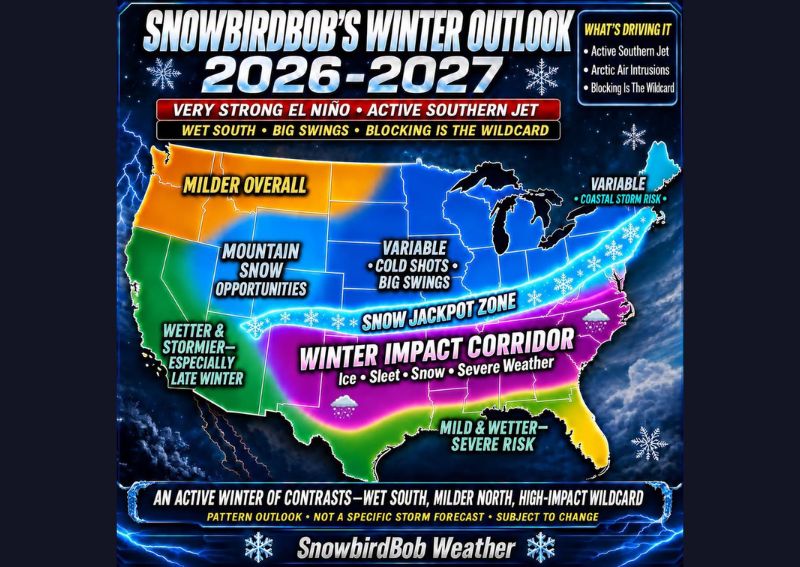
OKLAHOMA CITY, OK — A new early pattern-based winter outlook for 2026-2027 suggests the season ahead could bring an active winter marked by major contrasts across the United States, driven by a powerful Southern Jet, periodic Arctic air intrusions, and atmospheric blocking that forecasters describe as the ultimate wildcard. The outlook is built around what forecasters characterize as a very strong El Nino pattern, expected to fuel an active storm track across the southern tier of the country throughout the coming months.
A Winter Impact Corridor Stretches From Texas to the Southeast
The outlook identifies a Winter Impact Corridor stretching from Texas and the Southern Plains through the Mid-South and into the Southeast, an area forecasters say should watch for opportunities involving snow, sleet, freezing rain, and even severe weather throughout the winter season. This corridor represents the zone where forecasters expect the most frequent and varied wintry impacts, given its position along the path of the anticipated active Southern Jet.
The combination of ice, sleet, snow, and severe weather potential within a single corridor reflects the complex nature of winter storms in this transitional zone, where the exact precipitation type often depends on the precise placement of cold air relative to the storm track, a factor that can vary significantly even within short distances.
A Snow Jackpot Zone Spans the Central States
Perhaps the most closely watched feature of this outlook is what forecasters are calling the Snow Jackpot Zone, a corridor extending from the southern Rockies across the central states and the Ohio Valley, before curving northeastward through the major cities of the Northeast. Forecasters indicated that if Arctic air and the Southern Jet align at the right time within this zone, it could see significant snowfall potential during the coming winter.
This zone’s positioning directly beneath the broader variable, cold shots, and big swings category shown on the outlook map suggests it represents the boundary area where cold air and Gulf moisture are most likely to interact, creating the conditions necessary for significant winter storm development.
Deep South Trends Milder and Wetter With Storm Risk
The Deep South is expected to see generally milder and wetter conditions overall during the coming winter, according to the outlook, though forecasters cautioned that severe weather risks could accompany any stronger storm systems that move through the region. This combination of increased moisture and periodic severe weather potential is a common feature of strong El Nino winters, when an enhanced Southern Jet frequently transports Gulf moisture and energy into the southern tier of the country.
That severe weather risk within an otherwise milder, wetter pattern adds an important caveat for residents across the Deep South, suggesting the season could bring not just increased rainfall but also occasional stronger, potentially damaging storm systems mixed in with the generally milder conditions.
Central US Faces Big Temperature Swings
Forecasters highlighted the potential for big temperature swings across the central United States, with occasional strong cold shots punctuating what could otherwise be a more variable winter pattern. This kind of volatility, alternating between milder stretches and sudden intrusions of cold air, is consistent with a winter influenced by periodic Arctic air outbreaks interacting with a generally active but inconsistent jet stream pattern.
Residents across this region should expect a winter season that could feel unpredictable from week to week, rather than settling into a consistently cold or consistently mild pattern for an extended stretch.
Southwest Trends Wetter and Stormier Overall
The Southwest region is forecast to see wetter and stormier conditions overall compared to a typical winter, with forecasters specifically noting this trend should become more pronounced later in the winter season. Along with increased overall precipitation, the outlook points to meaningful mountain snow opportunities across the region’s higher terrain, a pattern consistent with a strong El Nino’s typical influence on the Southwest’s winter storm track.
This trend toward a wetter, stormier Southwest aligns with the broader strong El Nino signal driving much of this outlook, since El Nino winters have historically been associated with an enhanced subtropical jet stream that frequently channels Pacific storm systems into the southwestern United States.
Timing of Cold Air Will Determine Everything
Forecasters were direct in emphasizing that the timing of cold air intrusions will ultimately determine how this winter actually unfolds, noting that even a small shift in the storm track could mean the difference between cold rain, ice, or a major snowstorm for any given location. This sensitivity to timing reflects the inherently complex nature of forecasting winter precipitation type, where the exact placement of the freezing line relative to an approaching storm system can dramatically alter outcomes.
This caveat underscores why the outlook is presented as a broad pattern description rather than a location-specific forecast, since the eventual character of any individual winter storm will depend heavily on details that cannot be predicted this far in advance.
An Important Caveat About This Outlook
Forecasters were explicit in noting that this represents a broad pattern outlook rather than a forecast for any specific storm, and that the outlook will continue to evolve as the winter season approaches and more reliable data becomes available. This distinction is important for anyone interpreting the outlook, since the general zones and trends described represent likely tendencies rather than guaranteed outcomes for any particular week or storm system.
Given how far in advance this outlook has been issued, forecasters emphasized that continued monitoring and updates will be necessary as the actual winter season unfolds and the various factors, including El Nino’s strength and the timing of Arctic air intrusions, become clearer in the coming months.
What This Could Mean for Different Regions
With a very strong El Nino driving an active Southern Jet, periodic Arctic air intrusions, and the wildcard of atmospheric blocking all factoring into this outlook, residents across the United States could see a winter season defined by sharp regional contrasts, a generally wetter and milder South, a snow jackpot zone across the central states and Northeast, and a wetter, stormier Southwest, especially later in the season. As with any seasonal outlook, the specific details for any individual location will become clearer as winter approaches.
For continuing coverage of severe weather events and critical storm analysis across the United States, visit svhsnow.com.