SEATTLE, WA — A gloriously rainy morning is unfolding across much of Washington state, with much of the footprint of the Little Giant Fire near Plain receiving anywhere from 0.50 to 0.64 inches of rain, offering a meaningful boost to containment efforts on one of the state’s largest active wildfires. One nearby weather station recorded an even higher total of 1.06 inches just southeast of Plain, and forecasters say the rain is expected to continue in these areas for much of the day.
Widespread Rain Blankets the State
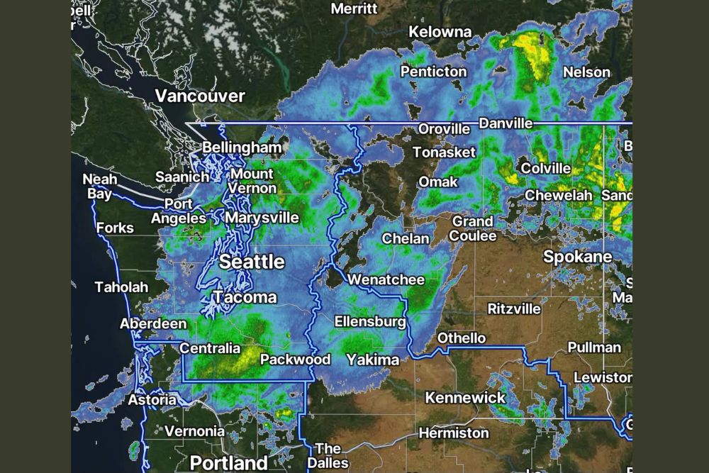
Radar imagery captured at 7:47 AM on Saturday, September 13, shows extensive rain coverage stretching across nearly the entire state of Washington, from Bellingham and Mount Vernon in the north through Seattle, Tacoma, and Olympia, and continuing east across the Cascades toward Wenatchee, Chelan, and into the Okanogan region. This widespread coverage reflects a significant, statewide rain event rather than an isolated or localized shower activity.
The rain’s reach extends well beyond the immediate fire zone, with substantial coverage also visible across eastern Washington near Spokane and stretching into portions of British Columbia, illustrating the broad scale of the weather system responsible for today’s rainfall.
Little Giant Fire Footprint Receives Meaningful Moisture
The Little Giant Fire, a lightning-caused wildfire that began on July 15 in the Chiwawa River valley near Plain in Chelan County, has burned approximately 163,000 acres and stood at roughly 27 percent contained as of recent updates, making it one of the largest and most significant wildfires in Washington’s worst fire year since 2021. Much of this massive fire footprint has now received between 0.50 and 0.64 inches of rain, providing welcome moisture to a landscape that has endured extreme fire behavior for nearly two months.
The higher total of 1.06 inches recorded just southeast of Plain represents an especially beneficial amount for that specific area, potentially helping to dampen fuels and reduce fire activity in one of the zones closest to the fire’s origin point near the Little Giant Trail.
Three Queens Fire Also Sees Beneficial Rainfall
Beyond the Little Giant Fire, the Three Queens Fire has also received meaningful rainfall, with up to 0.71 inches recorded across portions of that fire’s footprint. This additional rainfall represents good news for firefighting efforts across multiple active wildfire incidents in the state simultaneously, as the same broad weather system delivers beneficial moisture to more than one fire zone at once.
The combination of rainfall benefiting both the Little Giant and Three Queens fires underscores how significant today’s statewide rain event is for wildfire response efforts across Washington, given how many active large fires the state has been managing throughout this unusually severe fire season.
Rain Expected to Continue Through Much of the Day
Forecasters indicated that the rainfall currently affecting the fire zones is expected to continue for much of the day, extending the window during which firefighting crews can benefit from the added moisture and reduced fire behavior that typically accompanies sustained rainfall. This continued precipitation should further aid containment efforts as crews continue working to secure remaining fire lines.
The sustained nature of today’s rain, rather than a brief, passing shower, increases the likelihood of meaningful soil moisture recovery in the fire-affected areas, potentially helping to slow fire spread and reduce the intensity of any remaining active fire behavior within the footprint.
A Preview of Changing Seasons, But Not Full Autumn Yet
Despite today’s welcome rain, forecasters cautioned that residents should not consider themselves fully in autumn conditions just yet, noting that a drier, warmer stretch is expected to arrive later this week following today’s rain event. This suggests today’s rainfall represents a beneficial but temporary interruption to what remains an ongoing pattern of warm, dry late-summer conditions across much of the state.
That messaging offers a balanced perspective for residents eager for fall weather, acknowledging the genuine benefit of today’s rain for fire-affected areas while tempering expectations about a lasting shift away from summer-like conditions in the days immediately following this rain event.
What This Means for Fire Recovery Efforts
With significant rainfall now falling across both the Little Giant and Three Queens fire footprints, firefighting crews are positioned to make continued progress on containment as the added moisture helps suppress fire behavior and assists with securing remaining open sections of the fire perimeter. Given the scale of the Little Giant Fire and the extended effort already invested in fighting it, today’s rain represents a genuinely positive development for the ongoing incident response.
For continuing coverage of severe weather events and critical storm analysis across the United States, visit svhsnow.com.