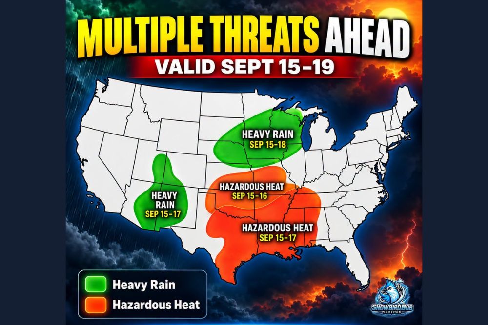
OKLAHOMA CITY, OK — The latest Day 3-7 U.S. Hazards Outlook is showing a stark split across the country for September 15 through 19, with heavy rain targeting parts of the Southwest and Upper Midwest while hazardous heat expands across a huge portion of the southern and central United States. That means while some regions brace for soaking rain and flooding concerns, others will continue baking in dangerous September heat during the same stretch.
Heavy Rain Targets Two Distinct Regions
The outlook highlights two separate zones expected to see heavy rain during the forecast period, with one area covering portions of the Southwest, roughly spanning from September 15 through 17, and a second, larger zone stretching across the Upper Midwest, valid from September 15 through 18. These two geographically separated rain threats suggest the national weather pattern during this window will feature multiple independent systems rather than a single storm affecting the whole country.
The Upper Midwest rain zone appears to cover a broad swath extending from the Dakotas through Minnesota, Iowa, and into Wisconsin, while the Southwest zone covers a corridor running roughly from Arizona through New Mexico and into West Texas, positioning both regions for potentially significant rainfall totals during their respective windows.
Hazardous Heat Expands Across the Southern and Central US
At the same time rain threatens the Southwest and Upper Midwest, hazardous heat is forecast to expand across a substantial portion of the southern and central United States, with the outlook showing two overlapping heat zones. One covers a broad area valid from September 15 through 16, while a larger, more expansive zone extends the heat threat through September 17, covering territory stretching from Texas and Oklahoma through the Mid-South and into the Southeast.
This heat zone’s sheer size, covering states including Texas, Oklahoma, Arkansas, Louisiana, Mississippi, and Alabama, along with portions of neighboring states, illustrates just how widespread the hazardous heat threat is expected to become during this period, affecting a substantial share of the nation’s population.
A Pattern of Extremes Playing Out Simultaneously
This outlook illustrates a broader pattern where two very different weather extremes are set to affect the country at the same time, with residents in some regions preparing for flooding concerns from heavy rainfall while residents in other regions continue to endure dangerous, potentially record-challenging heat. This kind of simultaneous extreme weather split is not unusual for early-to-mid September, a transitional period when the jet stream and broader atmospheric pattern can create sharply contrasting conditions across different parts of the country.
The scale of both threats, heavy rain covering multiple distinct regions and hazardous heat blanketing a huge swath of the southern and central U.S., underscores the complexity of the weather pattern setting up for the September 15 through 19 period.
What This Means for Affected Communities
Communities within the heavy rain zones, particularly across the Upper Midwest and Southwest, should prepare for the possibility of flooding concerns as the rain threat materializes during their respective windows. Meanwhile, residents across the broad hazardous heat zone spanning much of the southern and central United States should continue taking precautions against dangerous heat exposure, particularly given that this extended heat threat arrives well into what would typically be a transitional period toward cooler fall weather.
The outlook’s national scope means that no single region of the country is likely to escape some form of weather extreme during this five-day window, whether that comes in the form of heavy rainfall and flooding risk or continued hazardous heat.
Checking Your Specific Area
Given how sharply this outlook divides the country between rain and heat threats, residents are encouraged to check exactly where their specific location falls within the outlook, since the boundaries between the heavy rain zones, the hazardous heat zones, and areas expected to see neither extreme can shift meaningfully over relatively short distances. Communities positioned near the edges of either threat zone should pay particularly close attention to updated forecasts as the September 15 start date approaches.
What Residents Should Expect
As the September 15 to 19 period approaches, residents across the Southwest and Upper Midwest should prepare for the possibility of heavy rain and associated flooding concerns, while those across the broad swath of the southern and central United States under the hazardous heat outlook should continue monitoring conditions and taking appropriate heat safety precautions. This split pattern serves as a reminder that late summer and early fall can bring dramatically different weather experiences to different parts of the country simultaneously.
For continuing coverage of severe weather events and critical storm analysis across the United States, visit svhsnow.com.