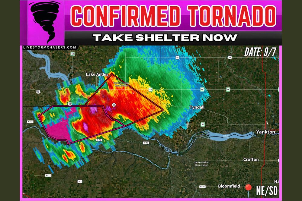
GROSS, NE — A confirmed tornado touched down over Gross, Nebraska, roughly eight miles northeast of Spencer, Nebraska, Sunday evening as a dangerous supercell thunderstorm tracked across the Nebraska-South Dakota border region. The National Weather Service office in North Platte confirmed the tornado at 736 PM CDT, prompting an Extreme Tornado Warning for central Boyd County that remained in effect until 815 PM CDT, with weather spotters on the ground verifying the touchdown as the storm continued moving northeast at 25 mph.
Storm Track Threatens Rural Boyd County Communities
The tornadic thunderstorm tracked through mainly rural sections of central Boyd County, an area dotted with small communities and public lands rather than dense population centers. The National Weather Service specifically warned that the storm would pass near the Parshall Bridge State Wildlife Management Area, Hull Lake State Wildlife Management Area, and the community of Anoka as it continued its northeastward path.
Highway 281 between mile markers 210 and 223 fell directly in the projected path of the tornadic storm, and officials urged any drivers in that stretch to seek shelter immediately rather than attempt to outrun the system. The warning carried language reserved for the most serious tornado threats, underscoring that this was not a marginal or borderline setup but a confirmed, ongoing tornado capable of significant damage.
Damaging Hail and Destructive Winds Compound the Threat
Alongside the confirmed tornado, the storm produced quarter size hail, a stone diameter capable of denting vehicles, shattering windows, and stripping siding from homes and outbuildings. The combination of a confirmed tornado and large hail within the same cell created a compound threat for anyone caught outdoors or in a vehicle as the system pushed through Boyd County.
Radar and spotter reports indicated the parent thunderstorm had been producing severe conditions for more than an hour before the tornado was confirmed, with an earlier severe thunderstorm warning issued for the same Gross-Spencer corridor citing 60 mph wind gusts and half dollar size hail. That progression from a strong non-tornadic cell into a confirmed, warned tornado illustrates how quickly supercells in this region can escalate once instability and wind shear align along the Nebraska-South Dakota border.
Mobile Homes and Structures at Elevated Risk
The National Weather Service explicitly cautioned that mobile homes in the tornado’s path would be damaged or destroyed, and that permanent structures could sustain damage to roofs, windows, and vehicles. Tree damage was also considered likely given the tornado’s confirmed intensity and the surrounding storm’s broader wind field. Flying debris was flagged as an immediate danger to anyone caught outside without adequate shelter, a hazard that persists even after a tornado has passed if debris fields remain scattered across roadways and properties.
Boyd County sits in a historically tornado-prone corridor along the South Dakota border, a region that has seen destructive supercells develop rapidly during the late summer months when warm, moist air collides with shifting frontal boundaries. Sunday evening’s confirmed tornado adds to a pattern of severe weather activity across the northern Plains this week, as multiple rounds of thunderstorms have brought damaging wind, large hail, and tornado threats to Nebraska and South Dakota communities.
Residents Urged to Monitor Conditions Closely
Emergency officials continued to stress that residents in and around Boyd County, Spencer, and the broader Gross corridor should remain weather-aware through the overnight hours, as additional rounds of severe thunderstorms remained possible given the unstable atmospheric setup in place across the region. Local officials and the National Weather Service typically recommend that residents in mobile homes or vulnerable structures identify a sturdy shelter location in advance, since a confirmed tornado warning provides only a narrow window to act.
The storm’s northeastward motion at 25 mph suggested it would continue affecting areas beyond the initial warning polygon before weakening, a trajectory that kept emergency management officials monitoring conditions closely into the evening hours. Sunday’s tornado in Boyd County serves as a reminder that the Nebraska-South Dakota border remains an active zone for severe convective weather well into early September.
For continuing coverage of severe weather events and critical storm analysis across the United States, visit svhsnow.com.