GREENVILLE, SC — A stunning stretch of October-like temperatures settled across western North Carolina and the Upstate of South Carolina for Labor Day, offering a dramatic and welcome break from the brutal heat that had gripped the region in recent weeks, with actual high temperatures running at levels considered normal for October rather than early September.
A Dramatic Cooldown Takes Hold
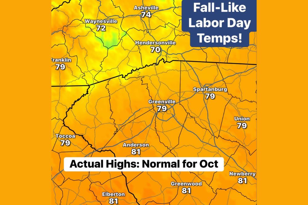
Temperature data from Labor Day showed a remarkable shift across the region, with Hendersonville reaching just 70 degrees and Waynesville climbing to only 72 degrees, readings that would be considered comfortably seasonal even in mid-autumn. Asheville followed closely at 74 degrees, while communities across the broader Upstate region, including Greenville, Spartanburg, and Union, all settled into the 79-degree range, a striking contrast to the sweltering heat that has dominated much of the late summer season across the Southeast.
Slightly warmer readings were recorded farther from the mountains, with Anderson, Greenwood, Newberry, and Elberton all reaching 81 degrees, still comfortably below the kind of oppressive summer heat that has characterized much of the region’s recent weather pattern. Even these slightly warmer readings across the Piedmont and foothills areas remained well within the range meteorologists consider typical for October rather than early September.
Why These Temperatures Feel So Remarkable
The significance of these readings becomes especially clear when compared to what the region has endured in recent weeks, with brutal heat having gripped much of the Southeast for an extended stretch prior to this cooldown. Following that kind of sustained, oppressive warmth, temperatures more commonly associated with October arriving on Labor Day itself represents a particularly dramatic and noticeable shift, one that meteorologists described as feeling absolutely fantastic after the difficult heat that preceded it.
This kind of temperature swing highlights just how variable early September weather can be across the Southern Appalachians and Upstate region, where a relatively minor shift in the broader atmospheric pattern can produce a night-and-day difference in how a given day actually feels compared to the same time just days or weeks earlier.
A Sign That Cooler Air Can Finally Push South
Beyond simply offering a pleasant one-day reprieve, this cooldown carries broader significance as the calendar moves deeper into the season. Meteorologists noted that this kind of temperature swing serves as a good reminder that the region is now reaching the point in the year when cooler air masses can finally begin making meaningful pushes farther south, a pattern shift that becomes increasingly common as September progresses and the broader atmospheric circulation begins its seasonal transition away from the persistent summer heat pattern.
While a single day of fall-like temperatures does not guarantee an early or lasting transition to autumn conditions, it does demonstrate that the atmospheric ingredients necessary for such cooldowns are becoming more available as the season advances, offering a preview of the kind of pattern changes residents can increasingly expect as fall approaches.
Don’t Get Too Comfortable, Heat Returns Later This Week
Despite the pleasant break, meteorologists were quick to caution residents against getting too accustomed to these comfortable conditions, with temperatures expected to climb back into the 90s later in the week. This return to more typical late-summer heat serves as a reminder that a single day or even a short stretch of fall-like weather does not necessarily signal a lasting pattern change, particularly this early in September when the region can still experience significant swings back toward summer-like conditions.
Making the Most of the Break
With such a rare and dramatic cooldown in place for Labor Day itself, meteorologists encouraged residents across the region to take full advantage of the comfortable conditions while they last, suggesting it was an ideal opportunity to open windows and enjoy the outdoor air given how quickly warmer conditions are expected to return later in the week.
What Comes Next for the Region
As this brief but welcome cooldown gives way to returning heat, residents across western North Carolina and the Upstate of South Carolina should prepare for a return to more typical early September conditions in the coming days. Meteorologists will continue monitoring the pattern for any additional opportunities for cooler air to push into the region as the month progresses and the broader seasonal transition continues to develop.
For continuing coverage of severe weather events and critical storm analysis across the United States, visit svhsnow.com.