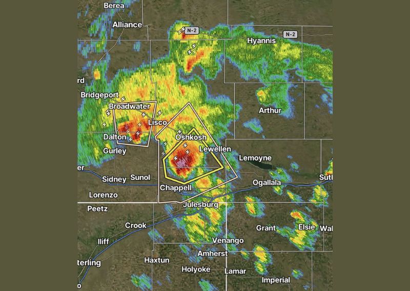
OSHKOSH, NE — A dangerous thunderstorm cell tracking through western Nebraska has prompted warnings for large hail up to 1.75 inches in diameter, with the storm moving directly toward the communities of Oshkosh and Lewellen. Radar imagery shows a well-defined, high-reflectivity core embedded within the storm, indicating the potential for damaging hail as the system continues its path eastward. The storm is also expected to affect the western side of Lake McConaughy, one of the largest reservoirs in the state and a popular recreational destination.
Storm Tracking Directly Toward Populated Areas
The warned storm cell is moving on a path that places it directly over Oshkosh and Lewellen, two communities situated along the projected track of the most intense portion of the cell. Radar data reveals a compact but intense core producing frequent lightning strikes, a hallmark of a storm capable of sustaining large hail production. Residents in the direct path of the cell are advised to seek shelter and move away from windows as the storm approaches.
Additional Cells Active Across the Region
Beyond the primary warned storm near Oshkosh, additional thunderstorm activity is visible across the broader western Nebraska and eastern Colorado region, including cells near Broadwater, Dalton, and Bridgeport. While these secondary cells have not been highlighted with the same warning as the Oshkosh storm, they reflect an active and widespread severe weather setup unfolding simultaneously across multiple counties in the panhandle region during the afternoon and evening hours.
Lake McConaughy Area in the Storm’s Path
The storm’s projected track extends toward the western side of Lake McConaughy, a significant body of water near Ogallala that draws boaters, campers, and anglers throughout the warmer months. Anyone on or near the lake within the storm’s path is urged to move to safe shelter immediately, as large hail combined with potential gusty winds can pose serious risks to anyone caught outdoors or on the water when the storm arrives.
Continued Monitoring Across the Panhandle
Meteorologists continue to monitor the evolving situation across the Nebraska Panhandle as this and other storm cells progress through the region. Given the presence of a well-organized hail core and the storm’s track toward populated areas including Oshkosh and Lewellen, residents throughout the warned area should stay alert to official updates and be prepared to take shelter quickly if the storm intensifies further as it continues moving east.
For continuing coverage of severe weather events and critical storm analysis across the United States, visit svhsnow.com.