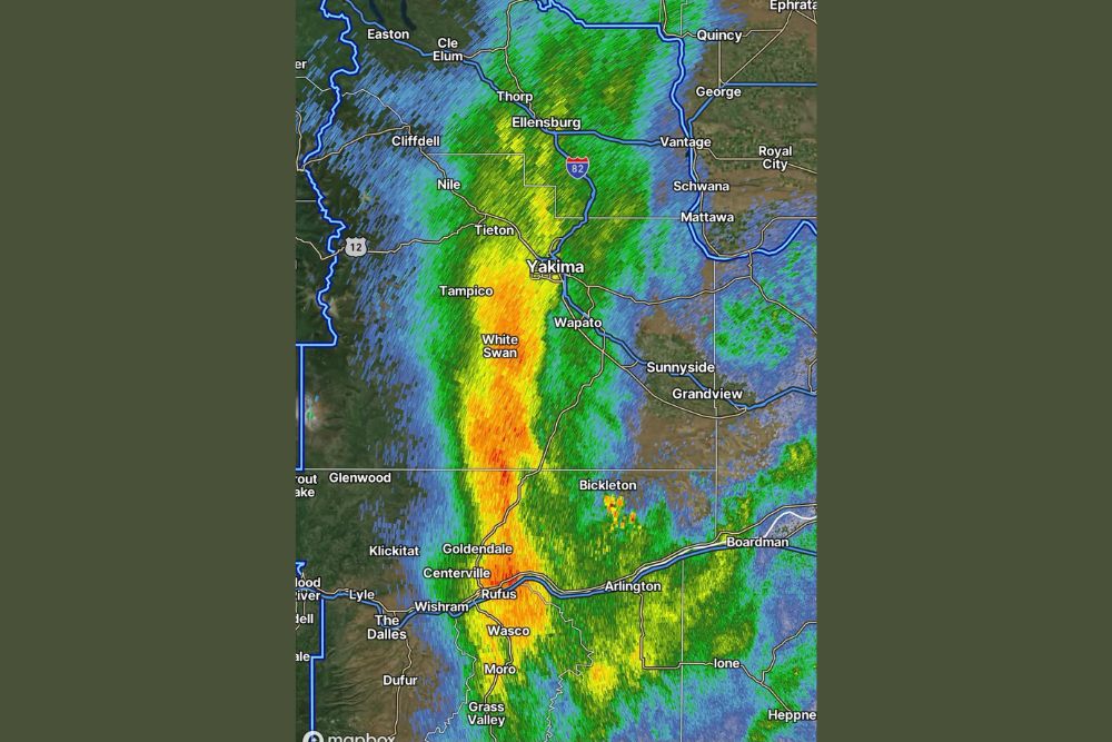
YAKIMA, WA — A steady, soaking rain is moving through central Washington tonight, with radar showing a well-defined band of moderate to heavy precipitation stretching from Ellensburg in the north down through Yakima and continuing south to Goldendale. The rainfall, confirmed on radar as of 7:43 PM, is delivering a substantial soaking to communities throughout this corridor, offering welcome moisture and the distinctive smell of rain to a region that has likely gone through a dry stretch.
A Defined Band of Heavy Rain Tracks South
Radar imagery shows a clearly defined, north-south oriented band of precipitation with the heaviest rainfall, indicated by deep orange and red coloring, concentrated in a corridor running from near Tampico and White Swan through Goldendale and continuing toward The Dalles at the Oregon border. This structured band suggests an organized area of rainfall rather than scattered, isolated showers, consistent with the kind of steady rain event capable of producing meaningful accumulation across the region.
The band’s north-south alignment appears to follow the general path of the Yakima River Valley and the Interstate 82 corridor, capturing communities positioned along that natural geographic and transportation corridor as the rain continues moving through the area.
Ellensburg to Yakima Sees Consistent Rainfall
Communities in the northern portion of the rain band, including Ellensburg, Thorp, and Cle Elum, are experiencing more moderate rainfall intensity based on the green and yellow coloring visible on radar in that portion of the state. As the band extends south toward Yakima, rainfall intensity appears to increase, with the Yakima area itself positioned near the transition zone between moderate and heavier rainfall rates.
This gradient in intensity from north to south suggests the atmospheric dynamics supporting this rain event are becoming more favorable for heavier precipitation as the system extends farther south, a pattern that continues to intensify as the band reaches into the White Swan and Goldendale areas.
Goldendale Sits Within the Heaviest Rainfall Corridor
The area around Goldendale appears to be positioned within one of the more intense sections of tonight’s rain band, based on the darker orange and red radar returns visible in that portion of the state. This heavier rainfall extends south across the Columbia River into portions of northern Oregon, including areas near The Dalles, Wasco, and Moro, indicating the rain band’s influence crosses the state line as it continues its southward track.
Communities throughout this heavier rainfall corridor should expect the most substantial accumulation from tonight’s system, particularly compared to areas farther east or west of the main band, which are experiencing lighter or more scattered precipitation.
A Welcome Change for the Region
The playful characterization of tonight’s rain as bringing a glorious petrichor, the distinctive earthy smell that accompanies rainfall after a dry period, suggests this rain event follows a stretch of drier conditions across central Washington. That context frames tonight’s steady rainfall as a welcome and pleasant change of pace for residents throughout the affected region, rather than an unwelcome or disruptive weather event.
This kind of steady, soaking rain, as opposed to brief, intense downpours, is often viewed favorably in regions dealing with dry conditions, since it allows moisture to soak into the ground more effectively rather than running off quickly during a more intense, shorter-duration storm.
Broader Regional Coverage Extends Into Oregon
Beyond the immediate Washington communities along the main band, radar shows the rain’s influence extending into portions of northern Oregon, with communities including Arlington, Boardman, and Heppner positioned near the eastern edge of the broader precipitation shield associated with tonight’s system. This cross-border reach illustrates the overall scale of the weather system responsible for tonight’s rainfall, extending well beyond a single, localized area.
The presence of some isolated, more intense returns near Bickleton, appearing as small pockets of yellow and orange within the broader green shading, suggests localized areas of slightly heavier or more convective rainfall embedded within the larger, more uniform rain band moving through the region.
What Residents Should Expect
Residents across central Washington, from Ellensburg and Yakima south through Goldendale and into northern Oregon, should expect continued steady rainfall through the evening hours as tonight’s well-organized rain band continues its southward progression. Given the sustained nature of this rainfall, drivers should exercise appropriate caution on roadways throughout the affected corridor as the system continues moving through the region.
For continuing coverage of severe weather events and critical storm analysis across the United States, visit svhsnow.com.