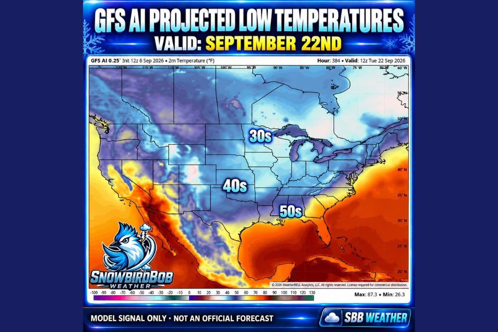
DES MOINES, IA — A long-range weather model is hinting that fall could be preparing to make a serious move south, with the 12Z GFS AI model projecting striking low temperatures for September 22nd that show 30s reaching parts of Iowa, 40s extending into Oklahoma, and 50s pushing all the way toward the Gulf Coast.
A Striking Cool Down Depicted on the Map
The projected low temperature map, valid for 12Z Tuesday, September 22nd, shows a dramatic and widespread cooldown blanketing much of the central and eastern United States. Temperatures in the 30s are shown stretching across a broad swath of the Upper Midwest and Great Lakes region, including areas surrounding Lake Michigan, Lake Huron, and Lake Erie, while 40s extend deep into the Central Plains and Ohio Valley, reaching as far south as Oklahoma.
Perhaps most notably, projected temperatures in the 50s are shown pushing all the way toward the Gulf Coast, a remarkable extent for cool morning lows this early in the fall season, suggesting that if this signal verifies even partially, much of the eastern half of the country could experience a genuinely autumn-like start to the day by late September.
A Long-Range Signal, Not a Confirmed Forecast
Meteorologists were careful to frame this projection appropriately, noting that September 22nd remains more than two weeks away from the model’s initialization date, a considerable distance for any forecast model to reliably pin down exact temperatures and their precise geographic placement. Given that distance, forecasters emphasized that the specific temperatures and boundaries shown on this particular model run will likely shift as the actual date approaches and additional data becomes incorporated into subsequent forecast runs.
Crucially, meteorologists stressed that this projection should not be interpreted as an official forecast at this stage, but rather as a long-range model signal worth watching closely as confidence in the details typically improves considerably as the timeframe in question draws nearer.
What It Would Mean if This Signal Verifies
Despite the necessary caveats surrounding a projection this far in advance, forecasters noted that if conditions anything close to what is currently depicted do verify, it would represent a major and widespread taste of fall reaching deep into the Southern United States. Temperatures in the 40s and 50s extending as far south as Oklahoma and the Gulf Coast region would mark a significant and welcome shift for areas that have experienced an extended stretch of late-summer heat throughout much of the preceding weeks.
This kind of widespread cooldown, if it materializes, would align with the broader seasonal expectation that early autumn increasingly allows cooler air masses to push farther south as September progresses, though the scale and reach depicted in this particular model run stands out as notably impressive even within that typical seasonal context.
Why AI-Enhanced Models Add a New Layer to Long-Range Forecasting
The use of an AI-enhanced version of the GFS model reflects a growing trend in meteorology toward incorporating machine learning techniques into long-range weather prediction, an approach that has shown promise in some cases for identifying broader pattern signals earlier than traditional model guidance alone. Even so, AI-enhanced long-range models remain subject to the same fundamental uncertainty that affects all forecasting at this range, since small errors and evolving atmospheric conditions can compound significantly over a multi-week forecast period.
Cooler Mornings on the Horizon
For residents across the Midwest, Plains, and even portions of the South who have endured a stretch of persistent summer heat, this developing signal offers an encouraging, if still uncertain, glimpse of cooler mornings potentially arriving by the back half of September. Meteorologists indicated they will continue monitoring subsequent model runs closely to see whether this cooldown signal holds, strengthens, or shifts as the September 22nd timeframe approaches.
Staying Tuned for Updates
As with any long-range model signal, residents across the affected region are encouraged to treat this projection as an early, evolving picture rather than a locked-in forecast for specific temperatures on a specific date. Meteorologists will continue providing updates as confidence in the pattern grows and the timeframe in question draws closer, offering a clearer picture of just how much of a fall preview the country might actually experience later this month.
For continuing coverage of severe weather events and critical storm analysis across the United States, visit svhsnow.com.