LITTLE ROCK, AR — Dangerously oppressive heat gripped Arkansas Saturday afternoon as heat index values soared well above 100 degrees statewide, with numerous locations reaching or exceeding the 110-degree mark, prompting forecasters to warn that the next several days offer no meaningful signs of relief.
Extreme Heat Index Values Blanket the State
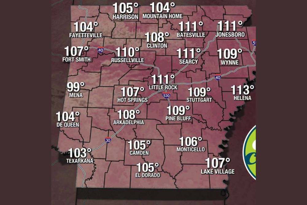
A future heat index forecast valid for 3:30 PM Saturday showed a striking swath of dangerously high readings stretching across nearly the entire state of Arkansas. Helena topped the list at a scorching 113 degrees, while Little Rock, Batesville, Jonesboro, and Searcy all reached 111 degrees. Russellville followed closely at 110 degrees, with Fort Smith, Wynne, Pine Bluff, and Stuttgart each registering 109 degrees on the heat index scale.
Even the state’s traditionally cooler northwestern corner was not spared, with Fayetteville reaching 104 degrees and Harrison hitting 105 degrees on the heat index, both well into the range considered dangerous for prolonged outdoor exposure. Only a handful of locations, including Mena at 99 degrees, stayed just below the triple-digit heat index threshold, underscoring just how widespread and intense Saturday’s heat proved to be across the state.
Why the Heat Index Matters So Much Right Now
The heat index, often referred to as what the temperature feels like to the human body, factors in both air temperature and humidity to reflect the true physiological stress placed on the body during hot weather. When heat index values climb into the 110-plus range, as was the case across much of central and eastern Arkansas Saturday afternoon, the risk of heat exhaustion and heat stroke rises sharply, particularly for anyone spending extended time outdoors without adequate hydration or opportunities to cool down.
This kind of extreme heat index reading, especially when it spans such a wide geographic area simultaneously, reflects not just hot temperatures but also an atmosphere holding an unusually high amount of moisture, a combination that makes the body’s natural cooling process through sweat evaporation far less effective than it would be in drier conditions.
Isolated Showers Offer No Meaningful Relief
While there was some chance of very isolated or widely scattered showers developing during the afternoon, forecasters were clear that any such activity would be of little significance in terms of providing relief from the heat. Showers that do develop under these conditions tend to be brief, localized, and insufficient to meaningfully lower temperatures or humidity across the broader region, meaning the vast majority of Arkansas residents should not count on any rain-driven cooldown Saturday.
No Signs of Relief in the Extended Forecast
Perhaps most concerning for Arkansas residents is the outlook for the coming days, with forecasters indicating the extended pattern shows continued very hot conditions with no signs of relief on the horizon. This persistence mirrors a broader pattern of stubborn late-summer heat that has gripped much of the South and South-Central United States, with upper-level ridging keeping temperatures elevated well beyond what would be considered typical for early September.
The sustained nature of this heat wave, rather than a single scorching day followed by a quick return to more moderate conditions, is what elevates the overall risk to public health, as cumulative heat exposure over consecutive days can be more dangerous than an isolated hot afternoon, particularly for those without reliable access to air conditioning or the ability to limit outdoor activity.
Staying Safe Over the Holiday Weekend
With Labor Day plans on the calendar for many Arkansas residents, forecasters strongly urged anyone heading outdoors to take extra care and prioritize safety given the extreme heat index values in place. Recommended precautions include staying well hydrated throughout the day, taking frequent breaks in air-conditioned or shaded areas, avoiding strenuous activity during the hottest afternoon hours, and checking on vulnerable neighbors, family members, and pets who may be more susceptible to heat-related illness.
Residents across the state are encouraged to continue monitoring forecast updates closely as the dangerous heat pattern persists, particularly given the lack of any clear break in the pattern currently showing up in extended guidance.
For continuing coverage of severe weather events and critical storm analysis across the United States, visit svhsnow.com.