MASON CITY, IA — Clear, calm weather is holding across southeast Minnesota and north Iowa early Friday, with a comfortable start to the day before clouds increase later. Temperatures and dew points are running from the upper 40s west of I-35 in north Iowa to the upper 50s in the Driftless region.
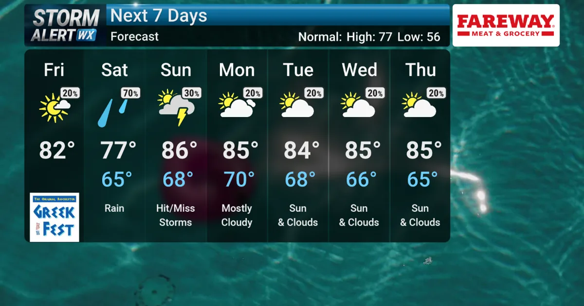
As the sun comes up, sunshine should dominate the morning. By afternoon, a few puffy cumulus clouds may develop as south winds return, helping temperatures climb into the low 80s. Dew points are expected to rise as well, reaching the low 60s in north Iowa and making the air feel more humid than earlier in the week.
Rain moves in late Friday night into Saturday
Clouds are expected to thicken after midnight as the next wave of rain pushes in ahead of a low-pressure system. Forecasters expect scattered rain with embedded rumbles of thunder to reach the area by Saturday morning.
Rain totals could be meaningful, with much of the region likely picking up between a quarter-inch and 1 inch. The wettest spots will depend on where the stronger bands set up. Precipitation may move out by Saturday afternoon, although a few showers could linger after the main round passes.
South winds will also strengthen on Saturday, especially during the afternoon. Gusts could reach 30 to 35 mph at times, which may add to the unsettled feel and create brief travel impacts where heavier rain falls.
Sunday could bring isolated storms and a severe risk
The weather pattern stays active into Sunday evening, when isolated thunderstorms may develop as a ridge-riding setup takes shape. The Storm Prediction Center has introduced a low-end severe weather risk for all of southeast Minnesota and north Iowa for Sunday.
Damaging wind and large hail are the main concerns if stronger storms form. The setup is being driven by a building ridge of high pressure from the south, which can help fuel warmer and more unstable air. The risk is described as low-end, but it is enough to keep attention on the late-day and evening forecast.
More heat and humidity return next week
After the weekend system moves through, the uncomfortable stretch is expected to continue into next week. High temperatures should settle into the mid 80s, while dew points rise into the mid to upper 60s.
That combination will make the air feel more muggy, and low-end chances for rain or thunderstorms may continue to linger. For now, the main changes are a wetter weekend, stronger Saturday winds, and a Sunday setup that could support a few stronger storms if conditions come together.
When the weather turns dangerous, SVH Snow is watching.