RALEIGH, NC — A little taste of fall is coming for a couple of days across parts of the South and East, with dew points showing a noticeably drier and cooler feel, particularly across North Carolina and South Carolina. Forecasters say this dip in humidity is arriving ahead of a mid-level low expected later this week that could bring rain and storms to the Southeast, moving through the Florida peninsula from the east.
The Carolinas See the Most Dramatic Improvement
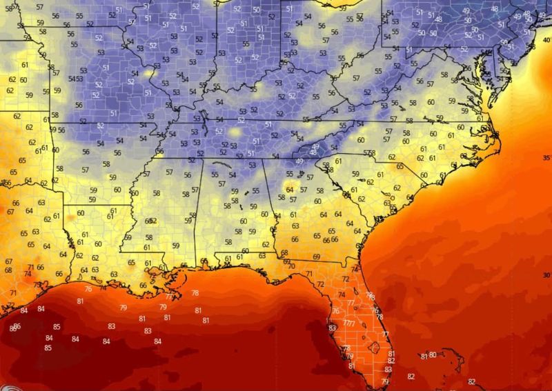
Forecast dew point data valid for Wednesday at 21z shows the most significant drop concentrated across central and eastern North Carolina and into South Carolina, with values falling into the striking 49 to 51 degree range across a corridor stretching from central North Carolina down through the Pee Dee region of South Carolina. This represents an unusually dry and comfortable reading for this part of the country in mid-September.
Surrounding areas within the Carolinas show a gradient of improving conditions, with dew points generally in the 54 to 58 degree range extending outward from the driest core, still representing a meaningful and noticeable improvement compared to the region’s typical late-summer humidity levels.
Georgia and Alabama See a More Modest Dip
Moving west into Georgia and Alabama, dew points remain somewhat higher but still show the effects of the drier air mass moving through, with values generally falling in the 58 to 66 degree range across much of those states. This more modest improvement reflects the gradient nature of the drier air’s reach, with the most dramatic effects concentrated closer to the Carolinas and gradually diminishing farther west and south.
Communities across the Gulf Coast states, including much of Alabama and Mississippi, are shown with dew points still in the low-to-mid 60s, suggesting these areas will experience a smaller, though still perceptible, shift toward more comfortable conditions compared to the more pronounced dry stretch expected across the Carolinas.
Florida Remains Firmly in Summer Mode
As is typical for this kind of pattern, Florida shows minimal change, with dew points remaining largely in the 60s to low 70s across the peninsula, including a notable 60-degree reading specifically highlighted over the central portion of the state. This continued humidity reflects Florida’s position farther removed from the drier air mass responsible for the more significant improvements farther north.
The persistence of higher dew points across Florida sets up an important contrast with the drier conditions expected across the Carolinas, illustrating how this particular pattern shift’s benefits are concentrated well north of the peninsula during this stretch.
A Mid-Level Low Threatens Rain Later This Week
Forecasters indicated that this brief dip in humidity is occurring ahead of a mid-level low expected to develop later this week, a system that could bring rain and storms to the Southeast before moving through the Florida peninsula from the east. This upcoming system represents the next chapter in the region’s weather pattern, following closely on the heels of this week’s temporary taste of drier, more comfortable conditions.
The timing of this mid-level low arriving on the heels of the current dry stretch suggests the Southeast’s brief fall-like interlude will likely give way relatively quickly to a return of more active, potentially wetter weather as the week progresses.
A Short-Lived But Welcome Change
The dip in dew points described in this outlook is characterized as a little taste of fall lasting only a couple of days for affected areas across the South and East, rather than a lasting pattern shift. This framing sets appropriate expectations for residents, particularly across the Carolinas, who should enjoy the drier, more comfortable air while it lasts before conditions trend back toward more typical late-summer humidity and the arrival of the anticipated mid-level low.
This kind of brief, temporary improvement is a common feature of early fall transitions in the Southeast, where genuine, lasting seasonal change often arrives gradually through a series of short pattern breaks rather than a single, decisive shift.
What Residents Should Expect
Residents across North Carolina and South Carolina should enjoy the noticeably drier, more comfortable air moving through this week, particularly around Wednesday, before conditions shift as the anticipated mid-level low approaches later in the week. Those farther south in Georgia, Alabama, and especially Florida should expect a more modest change, with Florida in particular likely to remain in its typical humid, summer-like pattern throughout this stretch.
For continuing coverage of severe weather events and critical storm analysis across the United States, visit svhsnow.com.