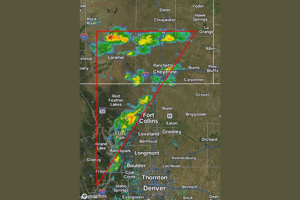
FORT COLLINS, CO — A few showers and storms developed across the northern Front Range of Colorado and southeast Wyoming this afternoon, with radar showing scattered activity concentrated within a triangular zone stretching from near Rock River, Wyoming down through Laramie, Cheyenne, and into Fort Collins. Despite the scattered storm activity, conditions remained pleasant across much of the region, with one observer reporting a gorgeous 70 degrees at home even as nearby storms produced periods of lightning and rain.
Storms Concentrate Within a Defined Corridor
Radar imagery shows the most active storm cells positioned within a roughly triangular area extending from southeast Wyoming down into the Colorado Front Range, with notable activity near Chugwater and Slater in the north, continuing south through the Cheyenne and Laramie areas, and further activity developing near Red Feather Lakes and Fort Collins to the south. This corridor captured the bulk of today’s shower and thunderstorm activity across the broader region.
Several storm cells within this zone displayed lightning strike indicators on radar, particularly in the area near Chugwater and along the I-80 corridor between Laramie and Cheyenne, suggesting these cells reached sufficient intensity to produce electrical activity even as the overall coverage remained scattered rather than widespread.
Southeast Wyoming Sees the Most Organized Activity
The most intense and organized area of storm activity appears concentrated across southeast Wyoming, particularly in a band stretching from near Chugwater eastward toward La Grange and Yoder. This area shows the deepest red and orange coloring on radar, indicating the heaviest rainfall rates and most vigorous storm development within today’s overall scattered pattern.
Additional storm activity was also visible near Cheyenne itself, along with scattered cells continuing south along the I-25 corridor toward the Colorado border, illustrating how the day’s storm development extended across a fairly lengthy north-south corridor spanning the state line.
Front Range Foothills See Scattered Development
Farther south, additional showers and storms developed across the Colorado Front Range foothills, with notable activity near Red Feather Lakes and extending toward Fort Collins. This activity appears somewhat more isolated compared to the more continuous band of storms farther north in Wyoming, consistent with typical afternoon convective development along the foothills during favorable atmospheric conditions.
The positioning of these Front Range storms, concentrated in the higher terrain west of Fort Collins and Loveland, reflects the common pattern of afternoon thunderstorm development along Colorado’s mountain-to-plains transition zone, where terrain-driven lift frequently triggers convection during the warmer months.
A Pleasant 70 Degrees Away From the Storms
Despite the presence of scattered showers and storms across parts of the region, conditions away from the active cells remained quite pleasant, with one local resident reporting a comfortable 70 degrees at their home. This kind of localized contrast, pleasant sunshine in one location while storms produce rain and lightning just miles away, is a common feature of scattered summer and early fall convective weather patterns across the Front Range and High Plains region.
That comfortable temperature reading suggests that for much of the broader region outside the specific triangular zone of storm activity, today offered generally favorable conditions for outdoor activities, even as isolated pockets dealt with passing showers and thunderstorms.
A Typical Late-Season Convective Pattern
Today’s setup, featuring a few scattered showers and storms across a defined corridor spanning the Wyoming-Colorado border region, reflects a fairly typical late-summer to early-fall convective pattern for this part of the country. These kinds of isolated to scattered storm days are common as the atmosphere continues to support some afternoon instability without the more widespread, organized severe weather setups more typical of peak summer months.
The limited coverage of today’s storms, confined largely to the highlighted triangular zone rather than affecting the entire region, meant that most areas outside the immediate storm corridor likely experienced the kind of comfortable, mild conditions described by the resident reporting 70-degree weather.
What Residents Should Expect
Residents across southeast Wyoming and the northern Colorado Front Range should continue to expect isolated to scattered shower and thunderstorm activity through the remainder of the afternoon and evening, particularly within the corridor stretching from Chugwater through Cheyenne, Laramie, and toward Fort Collins. Those outside the immediate path of these storms can continue to enjoy the pleasant, comfortable conditions reported across much of the broader region today.
For continuing coverage of severe weather events and critical storm analysis across the United States, visit svhsnow.com.