OKLAHOMA CITY, OK — A growing signal among long-range weather models suggests the persistent heat dome responsible for weeks of extreme heat across the Southern Plains will substantially weaken by mid-September, allowing at least weak weather systems to finally dip into the region and gradually increase moisture and rain chances across Oklahoma, Texas, and surrounding areas.
A Long-Awaited Crack in the Heat Dome
Forecasters tracking the pattern have identified a growing signal indicating the stubborn ridge of high pressure that has dominated the Southern Plains for an extended stretch is finally showing signs of weakening as the calendar moves toward mid-September. This kind of breakdown would allow weak weather systems, which have largely been deflected north and around the region for weeks, to begin dipping into Oklahoma, Texas, and the surrounding Southern Plains for the first time in what has felt like an extended stretch of unbroken heat.
Moisture and Rain Chances Building for September 14
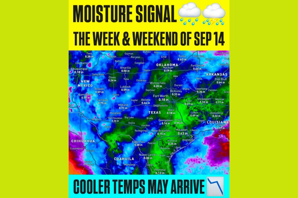
A moisture signal forecast map highlighting the week and weekend of September 14 illustrates the scale of the potential rainfall increase across the region. Projected precipitation totals show meaningful moisture reaching deep into Texas and Oklahoma, with Tulsa projected to see 0.63 inches, Fort Smith at 0.64 inches, and Midland and Abilene both showing totals above 0.6 inches. Farther south and east, Houston is projected to see 0.43 inches, while Lafayette, Louisiana, stands out with a notably higher projected total of 2.19 inches, suggesting the heaviest rainfall potential within this outlook may extend into the western Gulf Coast region as well.
Even typically drier areas of West Texas and New Mexico show projected moisture increases, with Roswell at 0.59 inches and Alamogordo reaching 0.79 inches, indicating this potential pattern shift could bring meaningful rainfall relief to a broad swath of the Southern Plains and Southwest rather than being confined to just the immediate Oklahoma and Texas core.
Slightly Cooler Temperatures May Also Provide Relief
Beyond the increased rain chances, forecasters indicated that slightly cooler temperatures may also accompany this developing pattern shift, offering a degree of relief from the persistent heat that has plagued the region for weeks. While any cooling associated with this pattern change is expected to be modest rather than dramatic, even a slight reduction in temperatures paired with increased cloud cover and rainfall would represent a welcome shift for residents who have endured an unusually prolonged and intense heat pattern throughout the late summer.
Confidence Remains Low This Far Out
Despite the encouraging nature of this developing signal, meteorologists were direct in acknowledging that confidence in the specific details remains low given how far in advance this outlook extends. Forecast signals for rainfall amounts, exact timing, and precise temperature departures nearly two weeks out are inherently subject to considerable change as new model data becomes available and the actual date in question draws closer.
Even with that necessary caveat, forecasters described the overall pattern change itself as encouraging, noting that the consistency with which multiple models are now depicting this moisture potential adds a meaningful degree of credibility to the signal, even if the finer details remain uncertain at this stage.
Climate Prediction Center Lends Additional Support
Adding further weight to this developing outlook, the Climate Prediction Center has begun highlighting parts of the Oklahoma and Texas region within a zone favored to see above-normal precipitation during the period in question. This kind of alignment between the blend of forecast models and the Climate Prediction Center’s own outlook strengthens the overall case that a genuine pattern shift may be taking shape, even as forecasters continue to caution that the specific details will likely evolve as the mid-September timeframe approaches.
What This Could Mean for the Region
Should this developing signal verify in some form, communities across Oklahoma, Texas, and the surrounding Southern Plains could see a meaningful and much-needed shift away from the persistent heat and dry conditions that have characterized much of the recent weather pattern. Increased rainfall would also carry the added benefit of helping ease any developing drought concerns that have accumulated across the region during the extended stretch of hot, dry weather.
Staying Tuned as Mid-September Approaches
Meteorologists will continue monitoring this developing signal closely over the coming days and weeks, watching for whether the models maintain consistency in depicting this pattern breakdown or whether the timing and magnitude shift as is common with outlooks extending this far into the future. As is typical, forecast confidence is expected to sharpen considerably as the week and weekend of September 14 draws nearer.
For continuing coverage of severe weather events and critical storm analysis across the United States, visit svhsnow.com.