HARRISBURG, PA — Another round of severe weather is expected Thursday across the eastern half of Pennsylvania, with the greatest risk arriving late Thursday afternoon and lasting through just after sunset. Forecasters say the main threat is damaging wind, but they are also watching for very localized hail and a small chance of a tornado in the strongest storms.
The setup comes during an active severe weather season that has already produced the third-highest tornado count in Pennsylvania recorded history. While late August often brings a drop in severe storm activity, this week’s pattern is keeping the state in play for another hazardous round.
What Forecasters Expect
Weather guidance points to an all-hazards severe thunderstorm threat for Thursday. In the highest-risk area, scattered severe thunderstorms are likely, with wind gusts up to 70 mph identified as the main concern. That level of wind can down trees, damage roofs, and knock out power.
Very isolated hail is possible in the strongest cells, and forecasters say a tornado cannot be ruled out. The severe threat is tied to decent wind shear, which can help storms organize and briefly rotate even if tornado coverage stays limited.
Some model guidance also suggests a separate cluster of storms and heavy rain could affect southeast Pennsylvania around lunchtime. Other guidance keeps that activity in New Jersey or drops it altogether, so the timing and placement of midday storms remain less certain than the evening threat.
Where The Strongest Risk Sits
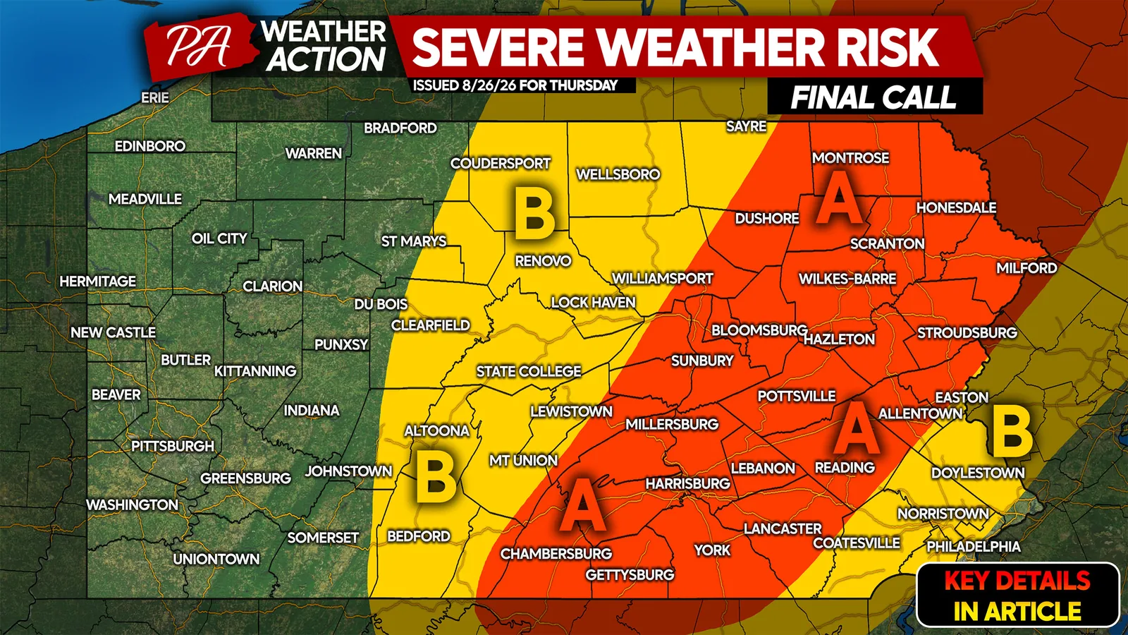
Area A is the more serious concern, where scattered severe thunderstorms are likely and damaging winds up to 70 mph are the top hazard. In that zone, hail is possible, and forecasters are not ruling out a tornado.
Area B carries a lower-end but still notable threat, with isolated strong to severe thunderstorms possible and damaging winds up to 60 mph as the primary risk. Even there, storms could become disruptive for people traveling or working outside.
The forecast covers the eastern side of the state, where conditions are expected to become unstable enough for storms to intensify late in the day. The exact placement of the strongest storms may shift as newer model runs come in.
What Residents Should Do Now
People with outdoor plans on Thursday should keep a close eye on updated forecasts, especially if they will be away from home during the afternoon or evening. The main window for dangerous storms is late Thursday afternoon through just after sunset, when visibility can drop quickly and winds can turn hazardous in a matter of minutes.
It is a good idea to make sure phones are charged, weather alerts are turned on, and any loose outdoor items are secured before storms arrive. Families should also know where to go if a warning is issued, since even a brief tornado threat can become dangerous fast.
Forecasters are urging residents to share the warning with family members and friends who may have plans outside Thursday, since the severe risk could affect travel, sports, work sites, and evening activities across parts of eastern Pennsylvania.
When the weather turns dangerous, SVH Snow is watching.